In order to provide indoor geolocation services, companies like Sweepin have to rely on 3D mapping of an establishment's buildings.
3D mapping, the basis of indoor geolocation
3D mapping of a building is a detailed representation of its structure, offering a realistic and comprehensive perspective. Drawing up a 3D plan enables you to visualize the height, shape and layout of a building's different levels.
A connection can be made to the Digital Twin to facilitate the creation and updating of a building's cartography. The Digital Twin is a real-time virtual reconstruction of a physical object or process, used to simulate, monitor and optimize its operation. In particular, this system enables more efficient resource management by simulating different layouts and space configurations to optimize plant utilization. It also enables proposed changes to be simulated and evaluated to minimize errors and costs.
Over time, the buildings of a facility, such as a hospital, are bound to evolve, be redeveloped or even restructured. Their mapping then needs to be updated to provide a consistently accurate map for geolocation services.
Quick and easy updating of building plans with intuitive tools
Updating a building's cartography can seem tedious if it includes a lot of changes. It's up to companies like Sweepin to make updating easier, especially when the changes don't affect the building's architecture.
Once the first 3D map has been created from the architect's plans, various elements of the plan, such as style, access features and points of interest, can be easily modified. Easy-to-use tools make it possible to quickly update all these mapping elements without calling in the professionals.
The flexibility offered by these tools guarantees an accurate, up-to-date representation of the environment. In this way, the building's functional evolutions are taken into account over time. This proactive approach to updating mapping contributes to efficient space management and optimal use of resources, particularly in facilities such as hospitals.
The case of Sweepin and its 3D plan editor
Sweepin uses the Digital Twin to provide its customers with their digital cartography. In addition to this, a 3D plan editor is entirely dedicated to the company's healthcare facility customers. This editor is easily accessible by any facility wishing to update its 3D mapping. It provides a range of features to give healthcare facilities control over certain elements of their cartography whenever they wish. The interface is intuitive and fluid, and each tool is clearly identified to simplify the updating process as much as possible.
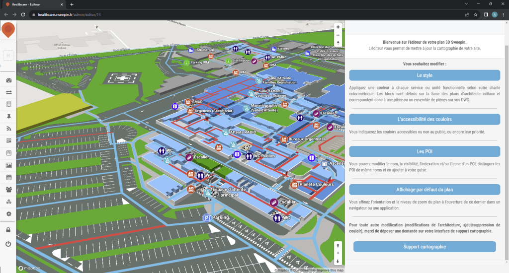
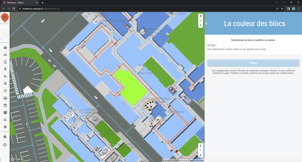
The style of a building can be easily modified, including its color. Changing the color helps to distinguish each department of a healthcare facility. It can be changed at will, but always strategically, especially when a department moves from one building to another.
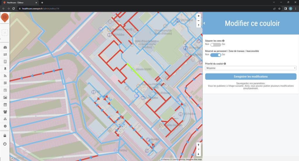
If required, it is also possible to quickly and easily change the accessibility of a building's corridors, by defining their priority and whether or not the public can use them. This can be useful for managing the flow of people through the building, or for preventing certain areas from becoming congested in an emergency.
Finally, it is also possible to add, modify or delete points of interest in a building, in case some of them change location or are removed during relocations.
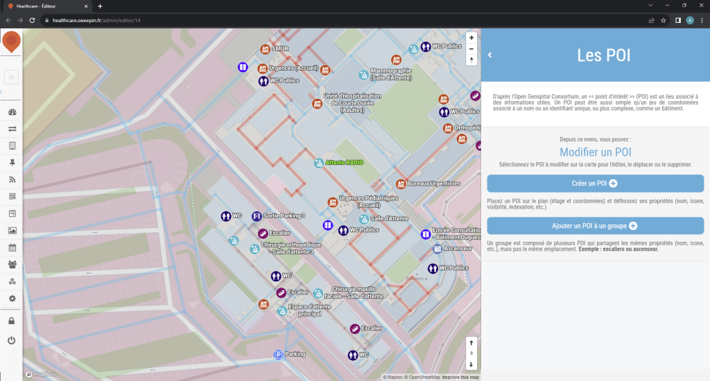
Major modifications, particularly to the building's architecture, can be carried out either via an automatic update of the Digital Twin, or by specialists due to their technical complexity and the time required to carry them out.
Around the world, connected cities are gaining ground, and with them, the use of mobile applications is becoming the norm. These mobile applications can make a significant contribution to enhancing the safety of a city's inhabitants, by facilitating communication between the various players involved in safety, enabling the rapid reporting of incidents or dangerous situations, and facilitating the intervention of emergency services in the event of an emergency.
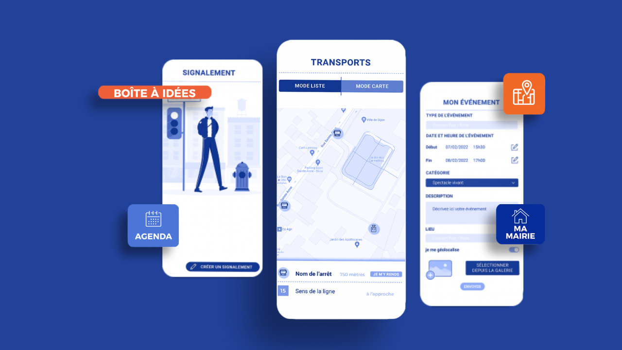
Mobile reporting applications for incidents
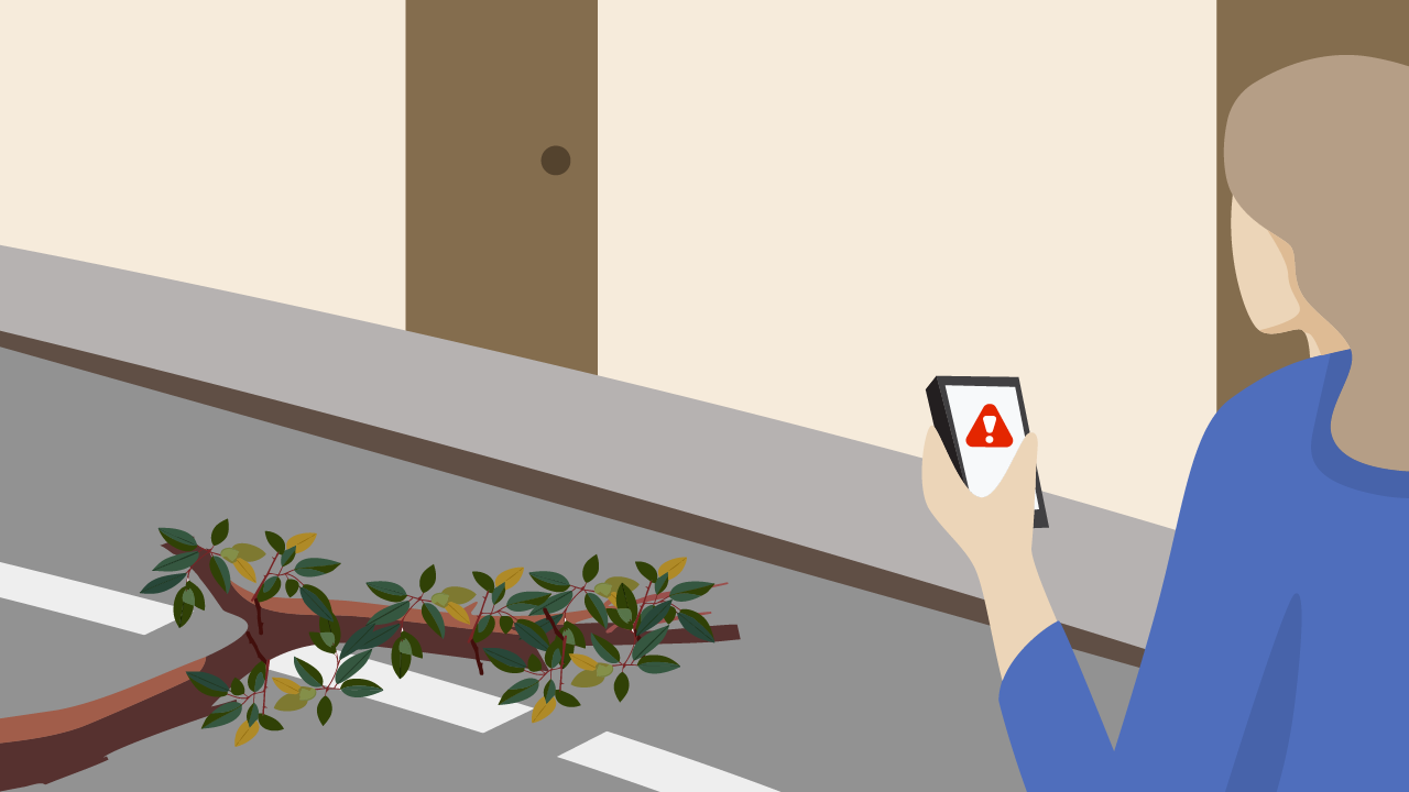
Mobile applications with a module for reporting incidents or dangerous situations on the public highway are gaining in popularity in smart cities. They enable citizens to quickly notify the appropriate authorities in the event of a problem. These applications can be used to report incidents such as road safety problems, acts of vandalism, fires, medical emergencies and so on.
These applications allow users to take photos or videos to describe the incident in greater detail. The data collected is then forwarded to the reports management service, which assesses the situation and deploys help if necessary.
Reports can be made anonymously by people who fear reprisals, or who do not wish to be involved in an investigation, for example.
As well as facilitating the reporting of incidents, these applications can also help the authorities to collect data on incidents occurring in the city. This data can then be used to identify the areas most at risk, to draw up action plans and improve safety, and finally to evaluate the effectiveness of the safety measures put in place on the territories.
It is important to note that for these mobile applications to be effective, it is necessary to ensure that the relevant authorities have the necessary resources to manage the information received and respond rapidly to emergency situations. It is also important to make citizens aware of the use of these applications, and to explain to them how to report incidents automatically and effectively.
Geolocation: a major asset for emergency services
Geolocation is another key tool for enhancing safety in connected cities. Mobile applications can use geolocation to enable emergency services to quickly locate people in danger during an emergency situation. This enables them to respond more quickly and effectively.
Real-time awareness and communication
Mobile applications also serve as communication channels, informing citizens in real time of dangers and instructions to follow in the event of an emergency, often via instant notifications.
Mobile applications represent a powerful lever for improving urban safety, in particular by optimizing communication between the various safety stakeholders. Find out more about our reporting module and all the other features available on our website!
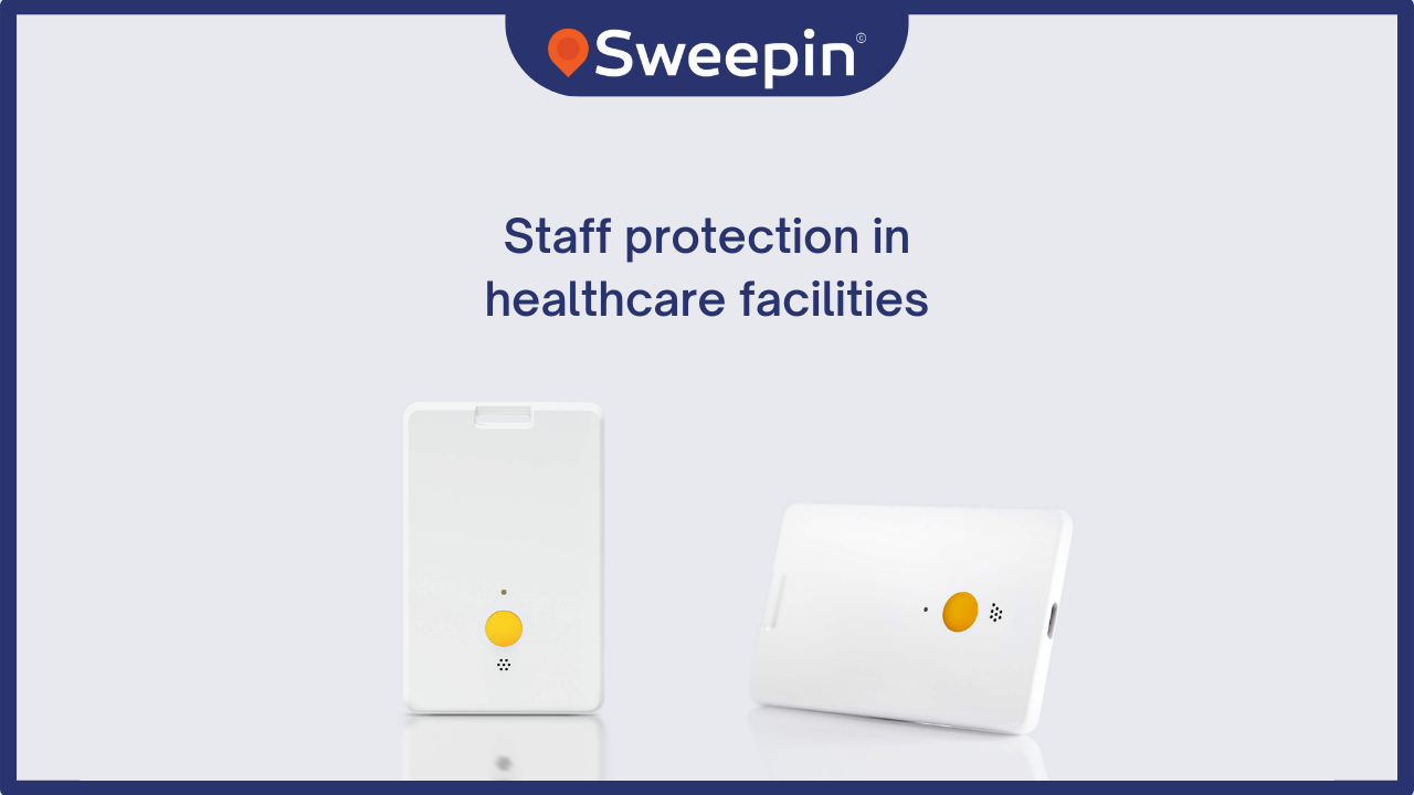
Healthcare facilities are demanding environments where staff safety is an absolute priority. Geolocation, when used thoughtfully and ethically, proves to be a powerful tool for reinforcing this security. In this article, discover the benefits of using geolocation to protect staff, thanks to solutions like the one offered by Sweepin.
Enhanced employee safety
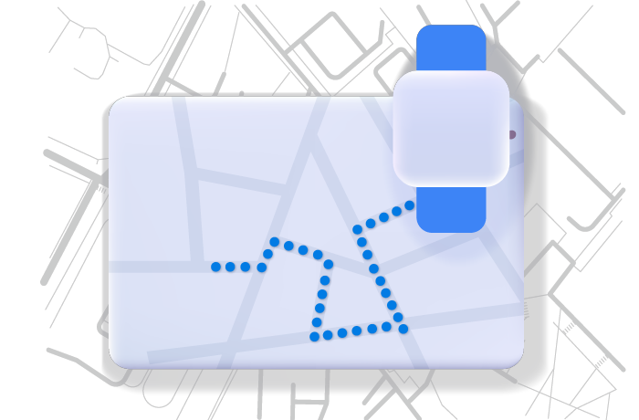
Staff safety in healthcare establishments is paramount, and geolocation offers an effective means of reinforcing it. When a member of staff feels in danger, solutions have been developed so that they can easily raise the alarm and be helped as quickly as possible.
For example, by being equipped with a badge or smartwatch, he can trigger an alert and thus activate his geolocation, enabling the security team to know his exact position instantly. This feature can save lives, as it enables faster intervention in the event of an emergency. By knowing where the person in distress is, rescue teams can reduce response times and maximize the chances of saving lives.
Staff stress is reduced and their privacy preserved
Thanks to this reinforced protection, staff stress and anxiety are reduced. Less stressed staff are more productive and healthier, which benefits staff, facilities and patients alike, who need the best possible care.
One of the key advantages of using geolocation via a smartwatch or badge is that it is not permanent. Geolocation is only activated when staff want it to be, by triggering an alert, thus guaranteeing their privacy and reinforcing their sense of security.
Incident documentation
Geolocation provides a digital trace of incidents, which can prove invaluable for internal investigations, safety reports and the prevention of potential future incidents. Accurate documentation contributes to in-depth analysis and the development of effective long-term solutions to ensure everyone's well-being and safety.
The thoughtful use of geolocation for personnel protection in healthcare facilities brings undeniable benefits in terms of safety, staff and patient wellbeing, but also in terms of prevention. It is imperative that companies offering these services put in place clear policies and comply with local regulations to ensure ethical and responsible use of this technology, while obtaining staff consent. Find out more about Sweepin's staff protection solution for healthcare facilities!
When you go to the hospital, the "journey" can be an obstacle course: finding the right building, completing admission formalities, getting to the right department on the right floor… we've all got lost at least once in the maze of hospital corridors. Thanks to a complete patient location and guidance solution, that's all over now! We explain how our patient guidance application works.
Why use a patient guidance application?
Whether you're a patient, a companion or a visitor, it's easy to get lost in these huge hospital complexes, and spend hours waiting to be admitted or obtain information. In the end, a lot of time and patience is wasted wandering the corridors, asking the nursing staff for directions… and the patient arrives stressed and late for his or her medical appointment 😤…
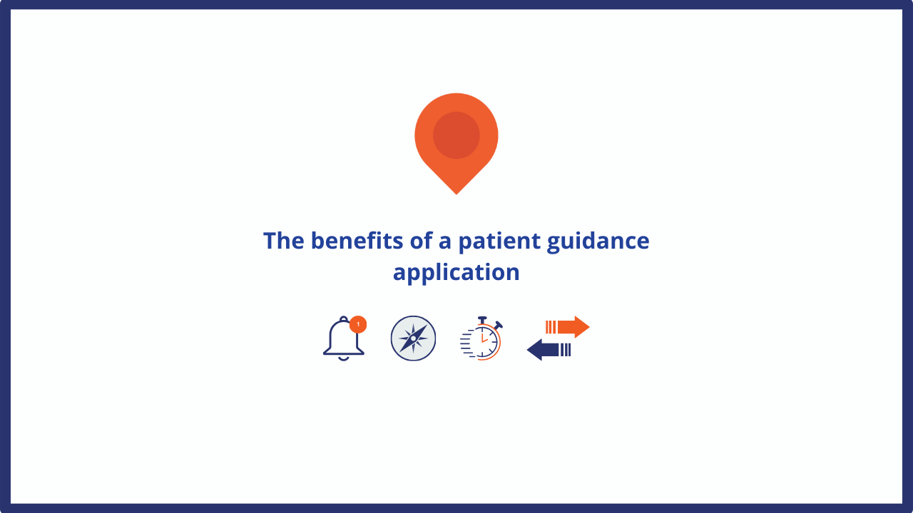
There are several advantages to using a guidance application:
- Patients/visitors immediately find their way from home to the hospital, then to the right department, waiting room or patient room,
- Patients save time by preparing their admission in advance,
- Care on arrival is faster,
- Hospital staff remain fully dedicated to their work,
- Patients arrive on time for consultation 😉.
Patient reception: localization makes it easy!
In practical terms, patients find their way around the hospital using the real-time guidance system. If they choose guidance without a mobile application, they simply scan the QR code located at the entrance to the building with their smartphone to access the digital map of the facility, enter the required department and follow the route step by step to their destination.
With the app, patient location and welcome functions are more extensive, with support at every step of the way:
- SMS appointment reminders,
- GPS guidance from home to hospital,
- Arrival detection, alerting the relevant department,
- Interior guidance (IPS).
With or without a smartphone app, the IPS operates off the mobile network, without beacons or Bluetooth to avoid interference with medical equipment. An audio function is included, notably to guide visually impaired patients 👍.
Save time with automatic patient admission
To optimize the patient's time at the hospital, the application enables automatic admission. When the patient receives the SMS appointment reminder, he or she can pre-admit online by scanning all the documents required for admission (Vitale card, convocation, prescription, etc.). Their personal data is hosted on the establishment's server in compliance with RGPD 🤫.
The documents are automatically transmitted to the hospital's software, so as to reduce processing times and better manage the flow of incoming patients. Once the patient has been detected in the facility, he or she receives a notification indicating his or her number in the queue to finalize admission. They can then continue their journey to their appointment.
The University Hospital Centres of Reims, Amiens-Picardie, Avignon… They have put their trust in Sweepin's location application. Contact us for more information.
At a time of ecological transition, municipalities are transforming themselves to become smart cities, intelligent cities that operate in a sustainable and collaborative manner in order to offer a more pleasant living environment to their residents. To achieve this, they use digital tools, especially mobile applications. But what are the advantages of a mobile application for smart cities? What exactly is it used for? Sweepin answers.
The practical benefits of a smart city application
The mobile application for smart city is a direct and efficient way to reach citizens. It is estimated that nearly 85% of French people have a smartphone, which makes the mobile application a practical communication tool, accessible to the greatest number and adapted to current uses.
The implementation of a mobile app also offers other advantages to the smart city:
- It is a flexible and agile tool, constantly updated and customizable according to the real needs of the city as well as the users,
- Well integrated with the city's information system, it offers productivity gains (less data entry, rapid processing of requests, etc.),
- The city reduces its expenses and improves its carbon footprint thanks to dematerialization, thus meeting the sustainable objectives of a smart city,
- Finally, it gives a modern and connected image of the city.
A mobile application to inform in real time
For an smart city, the role of a mobile application is first to inform users in real time. The advantage is that residents have instant access to all practical information about the city on the same medium: city hall opening hours, work zones, sorting guide, on-call pharmacies, new businesses, etc. The smart city's mobile app replaces and modernizes the traditional municipal magazine.
Beyond the inhabitants, the smart city app can also integrate tourist modules that will make visitors discover the city and its heritage, with for example interactive maps, hiking trails, panoramic views of points of interest… Whether you are a resident or a visitor, the mobile app is a mine of information!
Facilitate exchanges with a mobile app
The smart city application is not only informative. It integrates functionalities that allow to interact with citizens. This includes the possibility of carrying out administrative procedures at any time or to pay for the children's canteen, but also to participate in surveys concerning the city's projects.
The mobile app also allows you to report useful information such as damage, defective lighting or road accidents to the relevant departments: a citizen's report that makes the city safer and more pleasant to live in for everyone.
Through its various functionalities, a mobile application for smart city makes possible a shared governance between the city and its inhabitants. It facilitates interactions, strengthens citizen involvement and allows everyone to participate in the construction of a sustainable territory for tomorrow.
Discover all our connected solutions for smart cities.
In a medical or surgical ambulatory service, the follow-up of the patients' pathway
can be complex. Indoor geolocation is a precious help for the nursing staff.
care staff. Find out how to optimize the patient's journey in ambulatory care
and all the advantages that a geotracking system can offer to healthcare institutions.
to healthcare facilities.
Indoor geolocation and inpatient tracking
For a hospital, receiving outpatients requires well-trained logistics and the ability to manage the flow of patients and their companions. In this case, the implementation of an indoor geolocation system allows to optimize the management and the follow-up of the patients' journey in the department.
The principle is simple: several terminals are installed at each stage of the patient's journey (admission, entry into the recovery room, etc.). Upon arrival in the outpatient department, patients are equipped with a bracelet containing a geolocation tag. When the patient passes in front of one of the terminals, the beacon on the bracelet sends a signal to the nursing staff and the accompanying person, allowing them to follow the patient's journey in real time.
This geolocation system is not limited to use in an ambulatory service. It can also be implemented in an emergency department with the same objective of tracking the patient's journey, but it can also be used to locate patients at risk. Thus, when a patient gets lost or is detected outside a department or the hospital premises, the caregivers are immediately alerted.
The benefits of geolocation in an ambulatory service
Indoor geolocation solutions offer many advantages to all those involved in an outpatient's journey.
For caregivers, it is a simple and efficient way to manage and optimize the path of hospitalized patients, saving time in the administrative management of care. Geolocation allows them to follow the patient in real time, but also to manage the occupation of the care rooms, to detect congestion areas, to estimate the waiting time before the patient is discharged…, all from the establishment's interface.
For the patient, deprived of his smartphone during his outpatient hospitalization, it is the assurance that his relatives will be informed of his state of health as well as the time of his discharge. Their care and comfort are improved, and their waiting time is limited.
As for those accompanying the patient (family, friends, ambulance drivers, etc.), they are informed of their loved one's progress through the care process. They are not required to stay on site, which takes up waiting room space, and they will know exactly when they can pick up the patient.
With indoor geolocation, your healthcare facility can provide patients with better care during their outpatient journey. Sweepin offers hospitals a digital indoor geolocation solution to optimize the patient journey. Contact us for more information.
The terms "connected city" and "smart city" are often used to describe cities that use advanced technologies to improve the quality of life for their residents and make the city more efficient and sustainable. However, these terms have slightly different meanings and do not refer to the same type of city or community.
The connected city relies on technology to improve citizens' quality of life
The connected city is a concept that aims to improve the quality of life in the city through the use of technology to provide services to its citizens. Today, more and more cities are adopting connected solutions to better manage resources, optimize travel, improve safety, facilitate exchanges between citizens and city services, etc. The connected city is often implemented in a fragmented way, with solutions tailored to the specific needs of each city.
Mobile applications are one of the means used to make the city more connected. They allow citizens to interact with city services and to report problems on the public highway, such as accidents, deterioration of equipment, etc. They can also provide information in real time to the public. They can also provide real-time information on public transportation, events, local businesses, etc.
Created for connected cities, they can be customized according to the needs of each community. They can be developed to meet specific needs such as waste management, energy optimization, citizen safety, but also tourism development for example.
In order for mobile applications to be effective, a city must make sure upstream that this tool will be used by citizens, that it meets a real need. It is also important to have a reliable and efficient network infrastructure. The city must be equipped with appropriate communication networks to collect data in real time and process it efficiently, while protecting the privacy of users.
Mobile applications for connected cities are a key element to improve the quality of life in the city. They promote participatory democracy by allowing citizens to actively participate in the life of their community. This allows municipal services to better respond to the needs of the population.
The smart city and its broader vision of sustainable urban development and quality of life
The smart city is a more comprehensive concept that requires a strategic vision and a long-term project. A smart city goes beyond simple connectivity, using advanced and innovative technologies to improve the quality of life of its citizens, while reducing its environmental footprint and ensuring efficient use of resources. This implies the implementation of sustainable practices in all aspects of urban life.
A smart city relies on technologies such as data analytics, artificial intelligence (AI), cloud computing and 5G networks to collect and use data in real time. Smart cities also rely on transparent governance practices, citizen participation and open data to involve citizens and stakeholders in the planning and management of the city.
The main objective of a smart city is to create a sustainable and resilient urban environment that meets the needs of its citizens, while preserving natural resources.
A smart city takes a long-term view of sustainable urban development, considering long-term economic, social and environmental issues, while a connected city may focus on short-term technological solutions to meet specific needs.

IPS or Indoor Positioning System is a technology that allows to locate an object or a person inside a building. This device facilitates the management of interior spaces as well as the optimization of people flow. Discover all the advantages of an indoor positioning system.
A better orientation in a building thanks to IPS
Finding your way around is the number one advantage of an indoor geolocation service. This system allows occupants, visitors or emergency services to better orient themselves in a building to reach people or find objects. The navigation is done in real time and in full autonomy, which offers a fluid experience to the user.
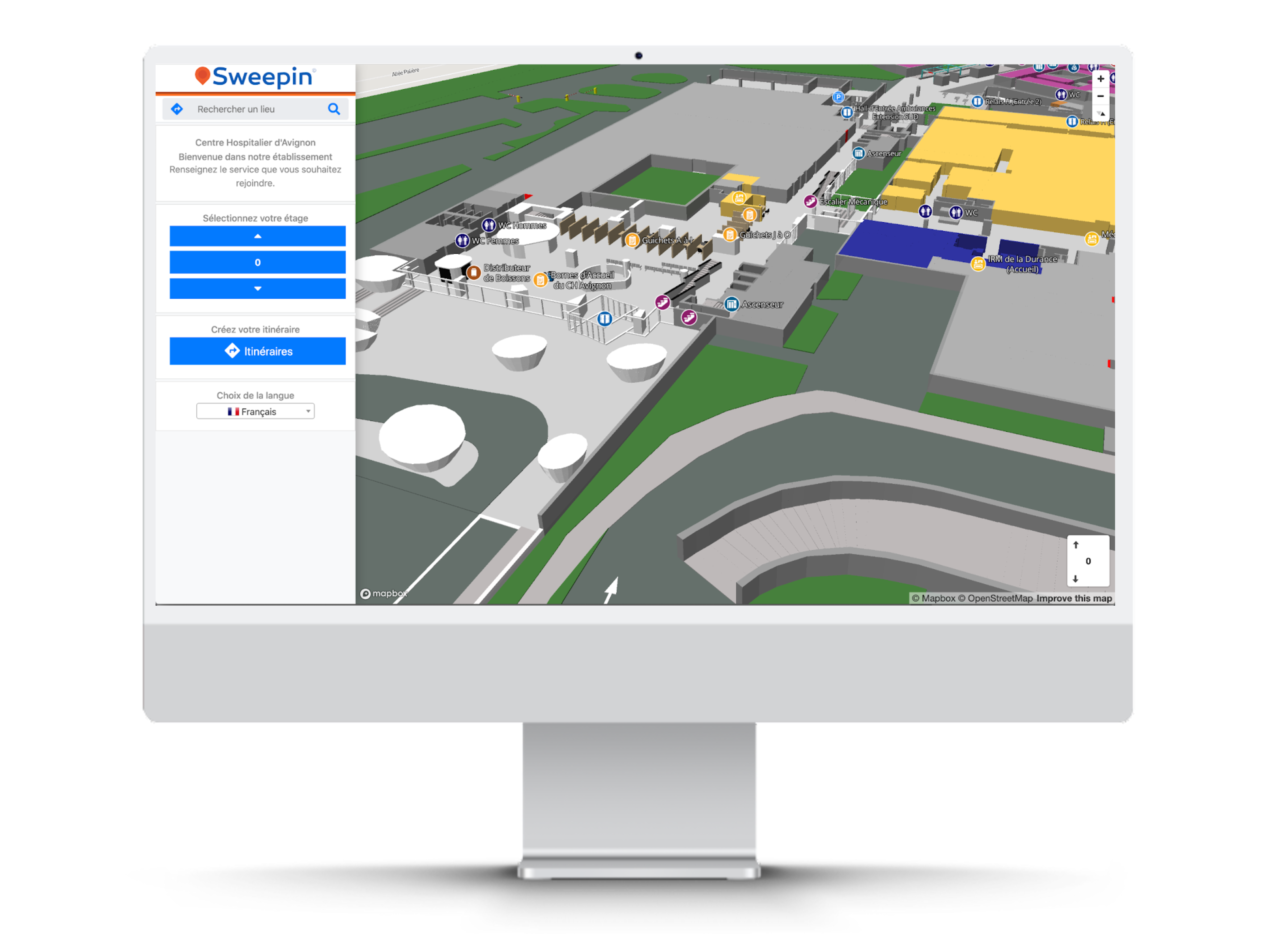
For an efficient and simple use of an indoor geolocation solution, it is first necessary to digitally map the entire building in order to obtain an accurate map of the premises. The building map is then available to everyone, without the need for a network or mobile application.
To access the map, visitors download the interactive map onto their smartphone, for example by displaying a QR code at the entrance of the building. This map can also be available on your website or a digital terminal, but also via a mobile application to facilitate the reception and guidance of visitors.
Locate people easily and accurately
The other advantage of the IPS is its ability to locate precisely people (or objects, as needed) in real time inside a building.
This is an asset for security, as it allows you to know when someone enters a restricted area, leaves the building or changes floors. In the event of an incident, this is a huge advantage for a security service or rescue team.
In a hospital, this indoor tracking system is particularly useful. It improves the patient's pathway in the ambulatory or emergency room because it can be used without a mobile network, and therefore without the risk of creating interference with medical equipment.
It also allows you to track the movements of at-risk patients, even outside the building, by coupling it to an external GPS. More reactive, more efficient, you gain in agility and security, simply by equipping each patient with a geolocation bracelet.
Collect and analyze location data indoors
Beyond simple location, an indoor geolocation service can become a great decision support tool. You collect useful data on activities in a building: pedestrian movements, frequency of passage, stopping times… Once analyzed, this information allows you to improve the use of space and resource allocation.
In concrete terms, a hospital can open a second reception point to reduce waiting time if it notices an influx of patients at admissions. A patient can be monitored within the facility throughout his or her hospitalization. Patients are also managed more quickly by healthcare staff, operational management of surgical procedures and supervision of different departments is improved.
By integrating an IPS solution into your information system, you get a relevant overview of the premises. Discover all our indoor geolocation solutions to better understand mobility in your company or your health establishment.

3D mapping and indoor geolocation offer a solution by making it easier and faster to find a destination. This technology provides precise step-by-step directions and navigation, improving the overall experience of patients and visitors in hospitals. It can be implemented on a mobile app or using QR Codes. Patients can find and locate a department or office on the hospital website prior to their visit. With a navigation app, they can get real-time directions directly on their mobile device.
Why set up a geolocation system ?
Getting to the hospital can be stressful and daunting, whether it's for an emergency, an appointment or to visit someone. Healthcare spaces are often large, complex and ever-changing, making navigation difficult. That's why hospitals should consider using 3D mapping and indoor geolocation to help patients and visitors navigate the hospital and provide quality care.
Navigating in a hospital can be challenging due to its complex layouts. Patients arriving at the hospital are often stressed and need help finding their destination quickly. Unfortunately, there are often few distinguishing features to guide them and many current navigation tools are not satisfactory.
What benefits?
Location-based services, such as security alerts and push notifications, can inform people of nearby sanitation stations or temporarily closed areas, such as hallways, restrooms or elevators.
With the flexibility of a geolocation and 3D mapping platform, managers can easily temporarily close off certain areas of the hospital. This ensures that geolocation is suppressed across these closed sites. For example, if a hallway or stairwell is too narrow to allow for social distance, navigation can be suppressed so that guests are not led to these areas. In addition to improving social distance, this technology can be used to control traffic flow in a hospital.
Another important feature of indoor geolocation technology is that the accessibility mode is automatically activated. This provides patients with accessible routes that use elevators and ramps rather than stairs. This is crucial in the healthcare sector, as it ensures a safe route from point A to point B.
Hospitals can also use indoor positioning to gain insight into their patients and visitors, and how they interact with the space. In turn, they can use this data to provide an improved and safer space. For example, if a large number of patients and staff members are looking for an elevator in a specific area, hospitals may consider installing one. All things considered, there are countless ways this technology can be used to keep everyone in the hospital safe.
Prospects for the future
We can see that 3D mapping and geolocation technology is improving the patient experience in healthcare. By implementing this technology, hospitals can reduce the frustration and stress that patients face when trying to navigate the maze of buildings, floors and departments. Being able to get people safely to where they need to go will not only save time and resources, but also improve patient and visitor satisfaction. This technology can also be leveraged to improve safety measures throughout the hospital and provide a consistent 3D mapping experience across multiple platforms.
Indoor mapping is already the future with intelligent indoor travel! Discover our 3D digital mapping solution and all our indoor geolocation services on Sweepin.en.

The smart city is a concept for improving the territory that relies on different technologies to offer a more pleasant living environment to the inhabitants, and that makes the management of public services more economical and ecological. But what are these technologies that are essential to the development of a connected city?
The role of technology in a smart city
Today, cities are facing several social challenges. They must control their energy consumption for both economic and ecological reasons, and optimize the way they operate in key sectors (transportation, health, security, etc.). All this while regularly informing citizens. A real challenge.
The smart city is a way to meet these challenges, and to achieve this, it uses different technologies such as IoT and connected networks to :
- Collect and analyze data in real time: these data allow us to assess the situation and to cross-reference large quantities of information in order to make the right decisions.
- Implement new tools or develop existing systems to act effectively and quickly.
For waste management, for example, intelligent sensors measure the number of garbage cans filled to organize their collection, artificial intelligence optimizes the next rounds, and an application shares a sorting guide with users. Thanks to these different technologies, the connected city meets the needs of citizens and improves their comfort.
Technologies to build the smart city of tomorrow
Among the technologies that are helping cities become more liveable and environmentally friendly, the Internet of Things (IoT) is fundamental.
In short, sensors collect data that is transmitted to a platform via a dense mesh of connected objects. The IoT uses long-range networks (5G, fiber, LPWA, LoRa…) for real-time data transmission. Once interpreted, the data can be used, for example, to adapt the city's water or electricity consumption.
To facilitate the processing of the massive amount of information, artificial intelligence (AI) complements the IoT. It analyzes complex data while applying corrective measures autonomously according to the results. It is a particularly effective technology in traffic light management and traffic control.
Geospatial technologies also play an important role in a smart city. They collect GPS, weather and topographic data to determine the needs and constraints of a specific location, whether static or dynamic. In the long term, they can be used to develop intelligent solutions that anticipate pollution peaks and climatic phenomena, the creation of new neighborhoods or the installation of wind turbines.
Finally, there is no smart city without information and communication technologies. They are a bridge between the population and the city, a means of accessing open data and participating in the life of the city. This includes practical apps that provide information on traffic, air quality, local merchants, heritage, etc., as well as citizen reporting applications. All of these technologies must also integrate data encryption solutions to prevent piracy, for an experience that is as effective as it is secure for the citizens of connected cities.
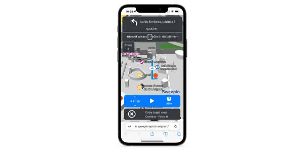
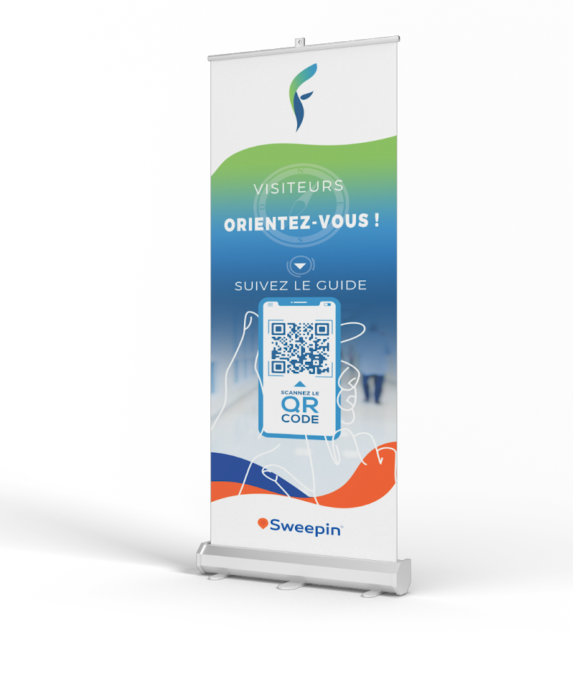
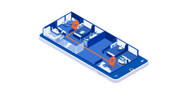
The indoor guidance system using QR codes allows users to easily get a map and directions to guide themselves through a building without having to download a mobile app. How does this technology work and what are the benefits?
3D mapping, the basis for the operation of interior guidance
In order to be able to offer interior guidance with QR codes, it is first necessary to create a 3D map of the building concerned. This mapping allows to represent all the spaces and particularities of a covered place so that the guidance is optimal. The smallest detail is important, it is therefore necessary to map the walls, corridors, rooms, but also the stairs and elevators for example.
Once designed, this 3D mapping allows to generate routes in the building in order to optimize the movements. It is only once this mapping is completed that it will be possible to set up the interior guidance with QR codes.
QR codes for quick and easy access
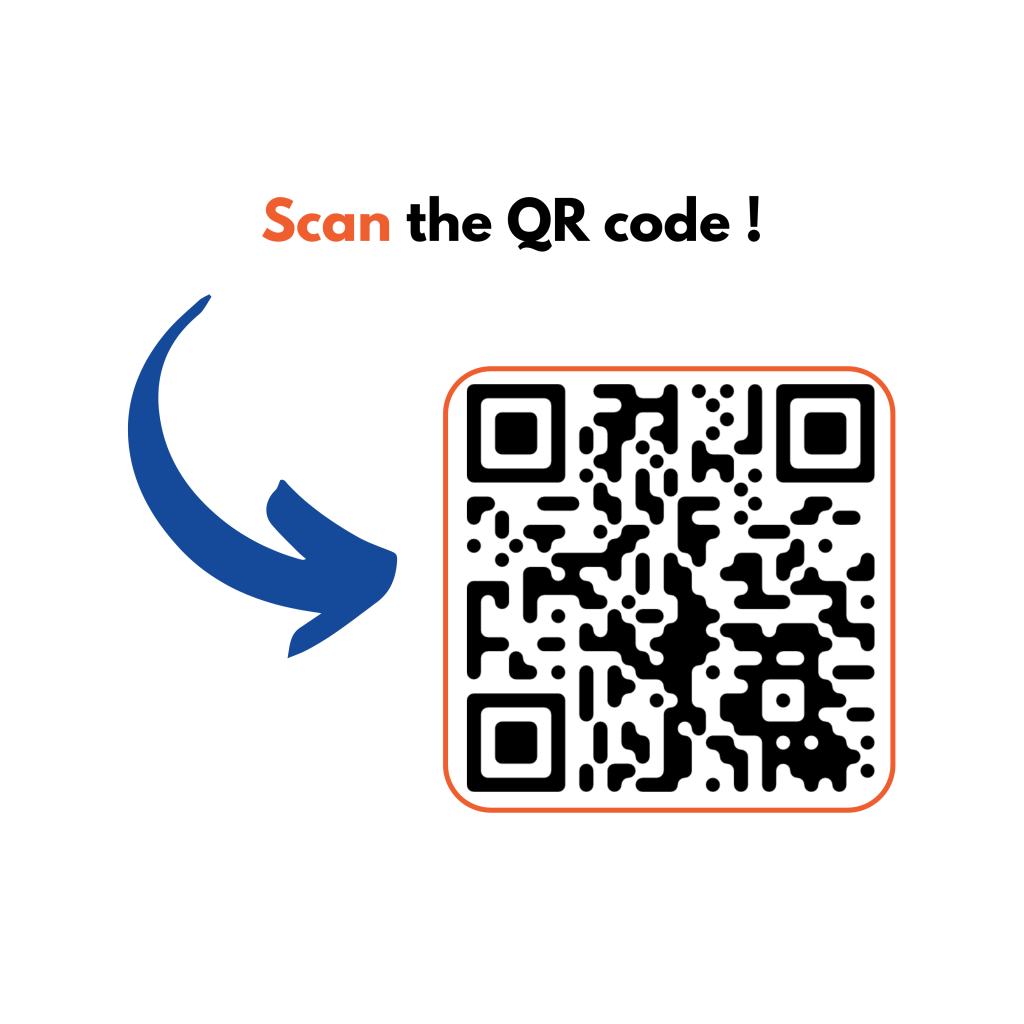
As a reminder, QR codes are a type of barcode that can be scanned with the camera of your smartphone, which then opens a web link or a file.
For this indoor guidance solution, QR codes are generated quickly from Sweepin's back office: up to a hundred can be created for a single building, which are then spread over the entire surface of the building.
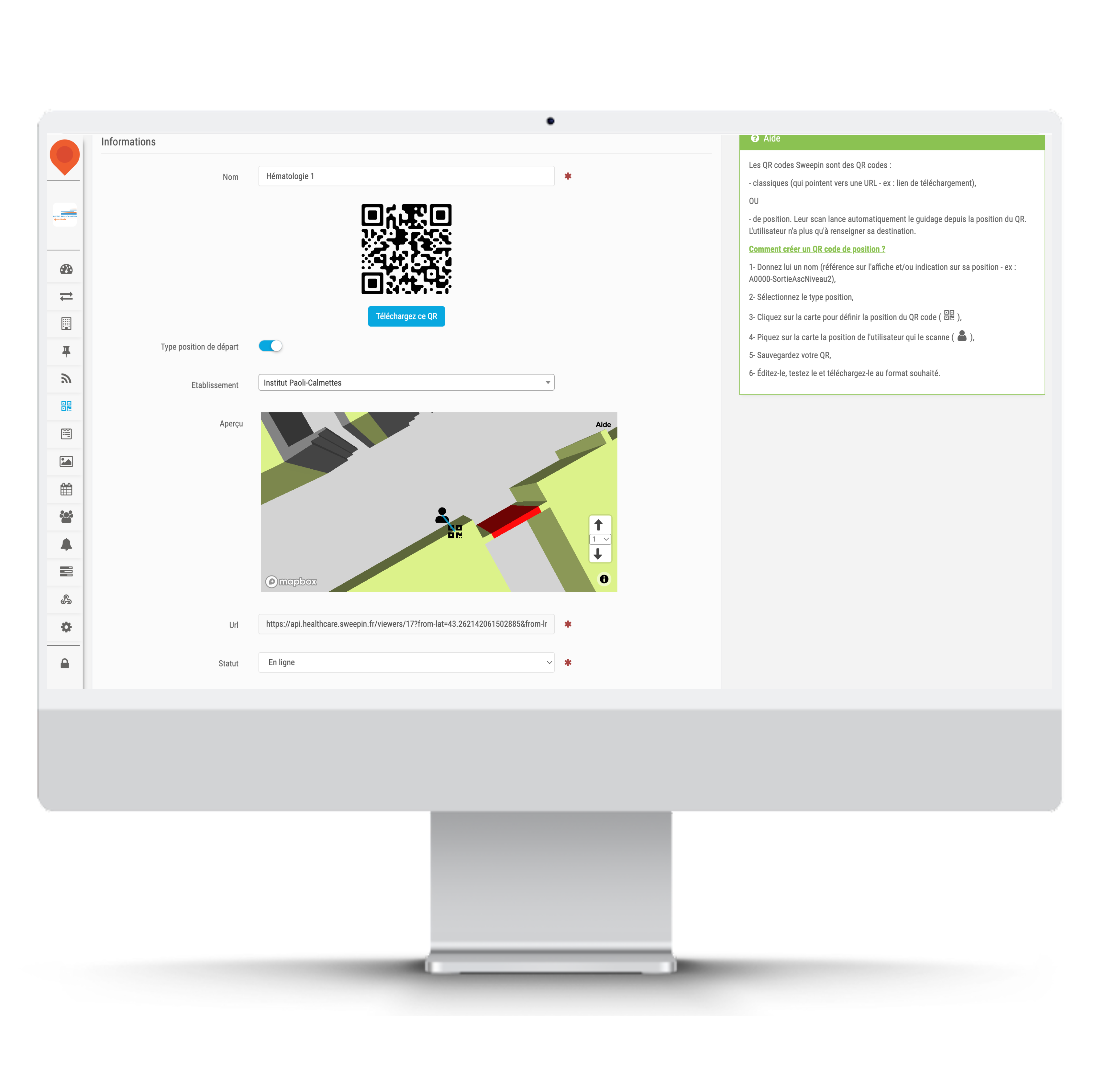
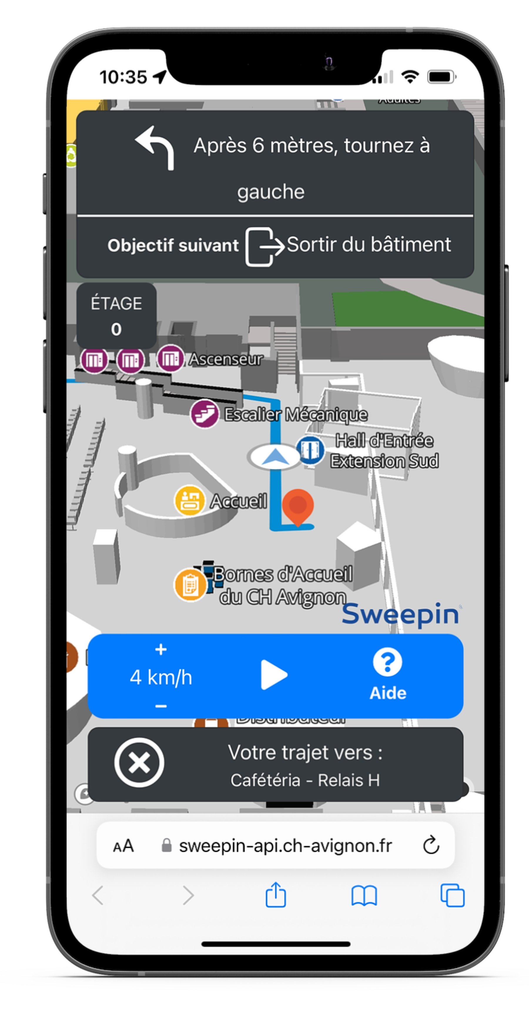
In this case, each QR code corresponds to the user's starting position in a building, such as a hospital for example. Once the QR code is scanned by the visitor with his smartphone, the map of the place is displayed on the screen. He is offered to generate an itinerary according to his position (found thanks to the QR code) and the place where he wants to go.
A button "start guiding" is then displayed and the visitor can choose his walking speed to follow the proposed route. He also has the possibility to pause the route at any time.
The availability of QR codes
Using this solution, the provision of QR codes for visitors is essential. It is possible to print them on posters or kakemonos for example, or to generate them on the digital terminals of the building. The main thing is that visitors find them quickly and easily in places that are often very spacious and busy.
Les avantages de cette solution de guidage intérieur
Combining 3D mapping with the use of QR codes has several advantages.
First of all, this solution does not require the prior installation of a mobile application by the visitors and allows them to guide themselves in the building without necessarily having anticipated this route search.
Moreover, the implementation of this guidance system is very simple because it does not require any installation, except for the kakemonos, posters or digital terminals of reception to display the QR codes. This means that the Sweepin team does not have to travel to help set up the service, as everything can be easily indicated remotely if necessary.
Another advantage is that visitors can go directly to the desired location without getting lost in a large structure. The staff also benefits from the reduction of corridor clutter, especially in health care facilities.
Finally, this solution can be adapted to many types of structures with large surfaces, such as healthcare institutions, trade shows, exhibitions, etc. Sweepin was responsible for the 3D mapping at the SANTEXPO trade fair in 2022 and is currently providing this solution to several healthcare institutions in France.
An access to statistics generated by the solution
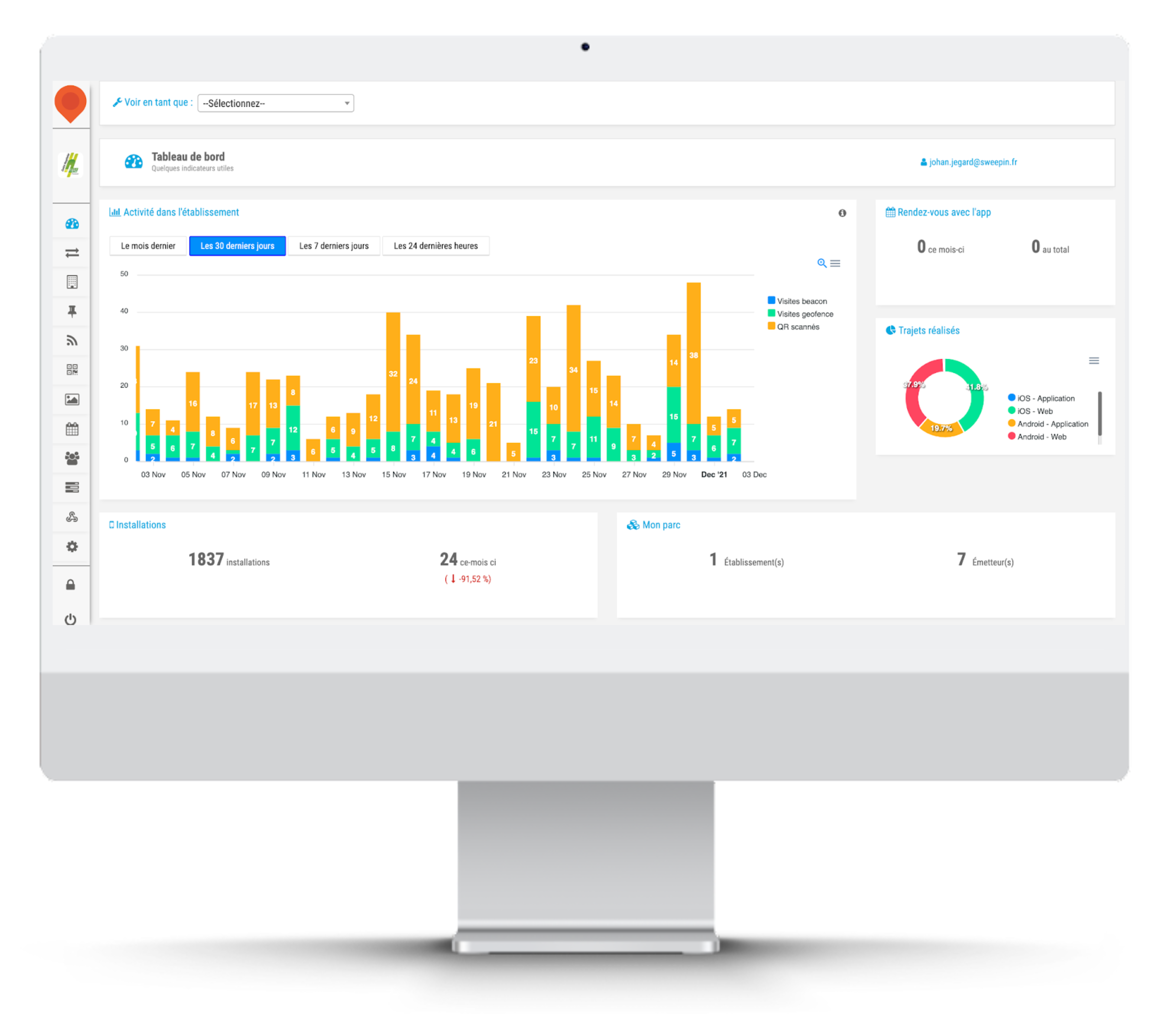
From the Sweepin back-office, it is possible to access numerous statistics on the use of the solution.
For example, you can see how many QR codes have been scanned since the solution was implemented, but also during the last 24 hours, the last week or the last month.
It is also possible to see which QR codes are the most scanned by visitors, as well as their number of scans.
These statistics make it possible to report on the effectiveness of the solution and to adapt it to the building in which it is deployed.
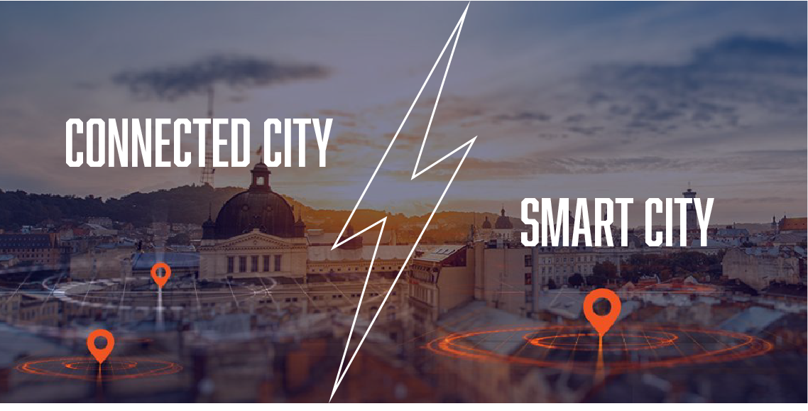
Connected city, smart city… These expressions are often used as synonyms, but isn't this an abuse of language? Is there a difference between these two concepts? Answers in this article.
What is a smart city ?
The concept of smart city, which appeared in Korea in the early 2000s, was popularized by former U.S. President Bill Clinton. For him, it is a sustainable city, with a low ecological impact and pleasant to live in. He then challenged companies specialized in computer networks to put their technology at the service of this city of the future and its inhabitants.
Today's smart cities are environmentally friendly and energy efficient, thanks to intelligent systems that enable them to anticipate their consumption: smart grids for water and energy management, sensors to manage public lighting, etc. It is also a place of exchange, where city services and citizens communicate via applications to improve city life together.
And what is the connected city ?
The connected city is a smart city! At the time when Clinton evokes the concept of smart city, we are at the very beginning of 2.0. The notion of participative economy was still in its infancy for the average citizen, and artificial intelligence was almost science fiction. The city then became, at first, a connected space through the use of technology. The goal is to improve the efficiency of processes to become more economical and ecological.
With the rapid evolution of technologies and mentalities, the city connected by purely technological means has then become an interactive space, in which residents participate in city decisions from their smartphones (citizen reporting, polling, etc.). It is a place for citizen dialogue, which brings people together, where everyone can take concrete action on their quality of life.
Smart city, connected city… So, different or not?
Connected city or smart city, the concept covers the same reality: that of a city optimized by technology. But is it really the same thing? Globally, yes, because to be smart, a city must be connected, and if it is connected, it has every chance of becoming intelligent, more sober on the ecological and economic level, and more inclusive on the social level.
There is, however, a semantic nuance. The notion of smart city refers to a thought, a real concept of urban planning in which we "build" a more sustainable and human city, while the term connected city refers rather to the practical aspect and the operational means to achieve it (open data, networked operation, mobile application, sensors, video protection cameras, etc.).
But whether it is called connected or smart, the city will only be a sustainable and pleasant place to live if it uses technology in a thoughtful way, with specific objectives: facilitating community life, reducing electricity consumption, optimizing waste collection, etc. Above all, it requires a real project and a municipal will to make technology an asset in the development of its territory.
Start your connected and smart city project with our applications with customizable services.

Interior mapping is the essential tool for finding your way around a building. Without it, you can only rely on your sense of direction to find your way around a building. This digital version of a map facilitates our understanding of spaces and transforms all our movements. But how does indoor mapping work in practice? Answer in this article.
Interior mapping: how does it work?
Digital interior mapping is the 3.0 version of the paper map displayed at the entrance of a building. It allows you to find your way in space in 3 dimensions, and it guides you in an intuitive and practical way to your destination. A dream tool for those who don't have a sense of direction!
To take advantage of the benefits of this solution, you first need an up-to-date building map. Just as your GPS needs the latest update of a road map to lead you to the right place by the right route, digital mapping requires up-to-date and accurate data. This map is then modeled into a 3D digital version, showing walls, elevators, stairs and floors.
Indoor mapping is a digital service but it is used without a mobile application or network. It is therefore practical and very easy to use. It is accessible via digital kiosks or via a simple QR code displayed on a kakemono at the entrance of the building. Visitors just have to scan it with their smartphone to access the map. At this point, they just need to enter their location and destination, then the video guidance system takes over to show them the way.
The concrete applications of interior mapping
Indoor mapping is mainly used to facilitate navigation and orientation of visitors. It can therefore help you find your way in any type of building, especially large complexes that receive the public (hospital, airport, station, hotel, etc.). In a warehouse, it is an effective solution to optimize the flow and facilitate the rotation of deliveries.
Because it provides a 3D view, digital mapping can also be used to locate points of interest in a building, no matter what floor they are on, such as stores on your route in a shopping mall, the mystery section in a library, or your location in an underground parking garage.
However, its applications go beyond simple orientation in a building. With indoor mapping, you can model specific routes and then make them accessible in web mode or via different QR codes. You can enhance the user experience at an event (visiting an exhibition in a museum, an open day at a university…), or increase safety by publishing routes to evacuation points in case of fire.
Indoor mapping is already the future with smart indoor travel! Discover our 3D digital mapping solution and all our indoor geolocation services on Sweepin.fr.
A few weeks ago, we introduced you to the characteristics of the smart city. A connected and sustainable city, in which technology is truly at the service of its inhabitants. Some of the French smart cities stand out. They are even among the 100 cities labeled "climate neutral and smart cities by 2030" by the European Commission. Here are our top 5.
1.Lyon, pioneer and leader in French smart cities
Lyon has totally rethought its urban planning over the past 20 years, and has taken advantage of this to integrate technology into its sustainable city model. It is a pioneer in smart grids, which use energy resources efficiently.
For a better quality of life, it has designed fully connected, green and less concrete eco-districts, such as the Confluence district. It is acting on mobility with electric and autonomous public transport, while giving pride of place to pedestrians and bicycles.
2.Dijon and its centralized management
In our Dijon hearts, Dijon is number 1, but we tried to stay objective 😊. To reduce its energy consumption by 65% by 2030, the capital of the Dukes of Burgundy has deployed sensors and created OnDijon, a unique control center that pilots the entire public space (traffic lights, lighting, parking…).
Residents interact with city officials via a collaborative platform, initiating coordinated actions in case of accidents or damage. Dijon is also building eco-neighborhoods that promote social diversity and encourage soft mobility.
3.Nantes, the smart city
Nantes has made its data accessible to involve residents in its transformation. More than 1.5 million Nantes residents log on to the open data portal every month to share their ideas on how to use this data in practice!
The Nantes dans ma poche app allows users to report incidents or obtain real-time information (air quality, traffic, etc.). And to continue the dialogue, public consultations on the energy transition or the deployment of 5G are organized for a co-construction of the Nantes of tomorrow.
4.Paris, greener and more connected
Like Nantes, Paris uses open data to develop collaborative projects. Many efforts are being made to renovate and green buildings. Alternative and electric modes of transport are becoming more widespread, and an autonomous metro is under study… The goal is carbon neutrality by 2050!
Paris is also betting on technology with, among other things, intelligent lighting and the Dans ma rue app to report damage. Coming soon, a digital access project for all and 5G available in the metros by 2025.
5.Grenoble, the ecocity of tomorrow
As the European Green Capital in 2022, Grenoble has developed its smart city project around the Cambridge eco-district, with the ambition of being an energy positive and carbon neutral territory.
The city has created a low temperature heating and cooling network. It manages all its energy flows with smart grids. It has also set up the Grenoble CivicLab for the participatory design of the city's digital services.
Montpellier, Bordeaux, Strasbourg, Roubaix, Chartres… Many cities are now intelligent. Discover how to connect yours with our services.
Location systems or GPS have become more and more important in our daily lives by simplifying our journeys, regardless of our destination. But what about our movements or the location of objects in buildings? For the past 15 years, indoor geolocation has been making steady progress to provide an effective answer to this question. Let's take a closer look at this technology with multiple uses.
Indoor geolocation in brief
You may have heard of IPS (indoor positioning system), indoor positioning or indoor geolocation? All these terms are synonymous with indoor geolocation, and refer to a set of technological solutions that allow the location of goods or people in closed spaces (buildings, houses, etc.).
For its implementation, indoor geolocation relies on several location technologies: Bluetooth beacons, RFID chips, Wifi and UWB signals for radio technologies, but also ultrasonic signals or the magnetic field. Depending on their shape and the desired use, they are disseminated in the building or mapped. The signals they emit are then picked up by various mobile devices, such as your smartphone or a touch pad.
Thus, indoor geolocation allows you to establish your position with an accuracy ranging from a few centimeters to several meters depending on the technology used, but also determine the route to take to reach your destination or the object sought.
Why not use a GPS?
Simply because GPS does not work indoors. Yes, this little jewel of technology that allows even those who have no sense of direction to find their way around the world, is unable to orient you in a building located around the corner! Why not?
In order to determine your position outdoors, GPS uses the radio signals emitted by the various satellites orbiting the Earth, but once inside, these signals are blocked by various obstacles (walls, roof, furniture …). The most recent GPS systems do receive a signal indoors, but their accuracy is still insufficient for proper orientation.
The other problem with a traditional GPS is that it processes the signal in a linear fashion, so it can't determine what floor you're on. Moreover, its signal decreases as you go downstairs, until it disappears in the basement. Hence the usefulness of an indoor geolocation system.
What are the applications of indoor geolocation?
Whether marketing, commercial or purely practical, the applications of indoor geolocation are numerous:
- Navigation and orientation in a public or private site (airport, hospital, shopping mall...) via a mobile application or a QR code,
- Behavioral analysis and flow optimization in a commercial space or a secured place (industrial site, military complex...),
- Gofencing: sending information to the user when he is in a specific area (promotional offers, security alerts...),
- Interaction with an object in the immediative vicinity (product, work of art...), etc.
The combination of different indoor geolocation technologies is managed via a platform, which can be integrated into the building information system. Sweepin offers innovative, unique and patented indoor geolocation technologies. Discover all our solutions on sweepin.fr.

The smart city is an original urban development concept that makes the life of city dwellers more pleasant and the management of territories more efficient thanks to technology. But what exactly is a smart city? How does it work and how is it connected? Here are some explanations.
Smart city, the city at the service of its inhabitants
Smart city, connected city, sustainable city… these innovative concepts have been around for about ten years but we know little about them. Yet they meet the aspirations of many French people who are looking for meaning in their daily lives: being more involved in the community, saving resources, communicating simply, using efficient public services…
Public authorities are often perceived as immovable systems, not very agile in their mode of operation and in the answers they provide to citizens. A deaf and blind system, in which today's citizens have difficulty making their needs heard and sharing their ideas.
In a smart city, or a smart territory outside the metropolis, it is the opposite. City services use digital tools to exchange with residents and improve their operational efficiency in managing infrastructures: transportation, urban planning, health, environment, etc. It's the city 3.0 at the service of its residents.
How does a connected city work?
The objective of a smart city is to make the city a sustainable space in several ways:
- Offer a better quality of life through active paticipation of citizens,
- develop envrionmental initiatives based on sustainable urban planning, intelligent resource management and the growth of the local economy,
- Improving public services, especially by making administration efficient and urban transport effective.
To achieve this, communities rely on technology, such as applications to exchange open data with citizens, and artificial intelligence to improve infrastructure and provide an agile response to residents' needs. In this sense, the smart city is also a connected city.
More collaborative, more agile, the smart city is also more ecological and more efficient. Let's not forget that smart also means astute, clever; the smart city therefore skillfully combines the advantages of technology with collective intelligence for a better quality of life and service.
Smart cities and their concrete applications
A smart city is in a way the proximity of yesterday (exchanging on the village square) with the technology of today (the Internet of Things) to build the life of tomorrow (ecological and pleasant spaces to live).
However, there is no single mode of action. Each smart city develops its vision of the ideal smart city and chooses the technology to get there: citizen reporting apps, connected services to promote local commerce, sensors to improve waste collection…
Lyon relies on passive construction and smart grids to adjust electricity supply. Nantes uses open data and an app dedicated to mobility (real-time traffic, incidents on public roads, etc.). Dijon centralizes the management of urban equipment (traffic lights, video protection, etc.) and saves money with LED lighting. And for you, what is the ideal smart city?