Blog-en


The indoor guidance system using QR codes allows users to easily get a map and directions to guide themselves through a building without having to download a mobile app. How does this technology work and what are the benefits?


3D mapping, the basis for the operation of interior guidance


In order to be able to offer interior guidance with QR codes, it is first necessary to create a 3D map of the building concerned. This mapping allows to represent all the spaces and particularities of a covered place so that the guidance is optimal. The smallest detail is important, it is therefore necessary to map the walls, corridors, rooms, but also the stairs and elevators for example. 


Once designed, this 3D mapping allows to generate routes in the building in order to optimize the movements. It is only once this mapping is completed that it will be possible to set up the interior guidance with QR codes.


QR codes for quick and easy access


As a reminder, QR codes are a type of barcode that can be scanned with the camera of your smartphone, which then opens a web link or a file. 


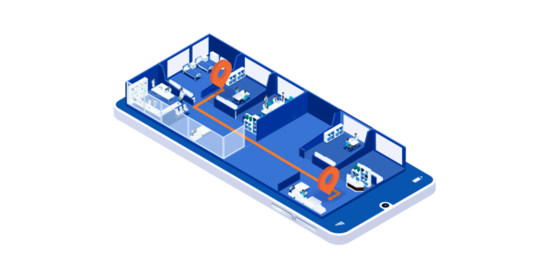
For this indoor guidance solution, QR codes are generated quickly from Sweepin's back office: up to a hundred can be created for a single building, which are then spread over the entire surface of the building.


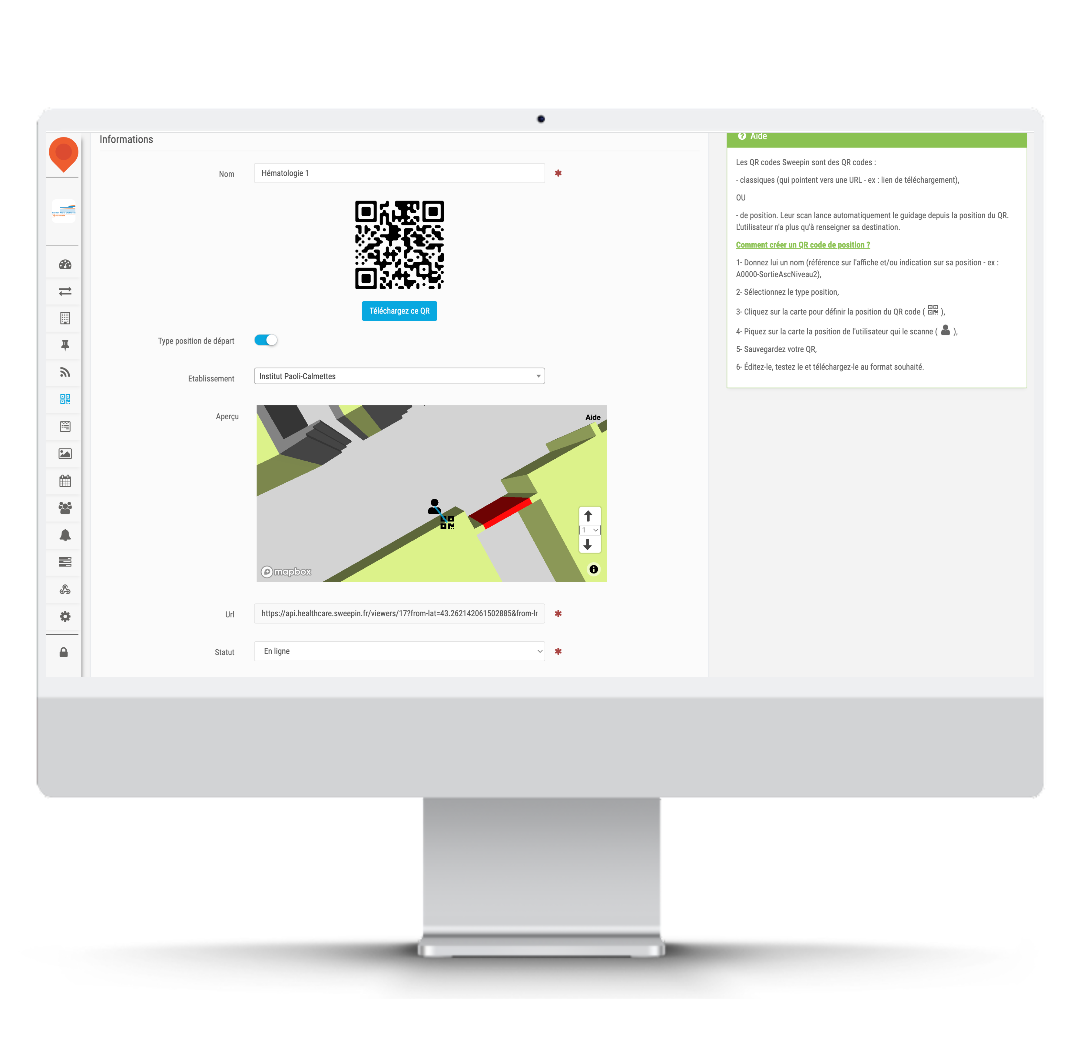
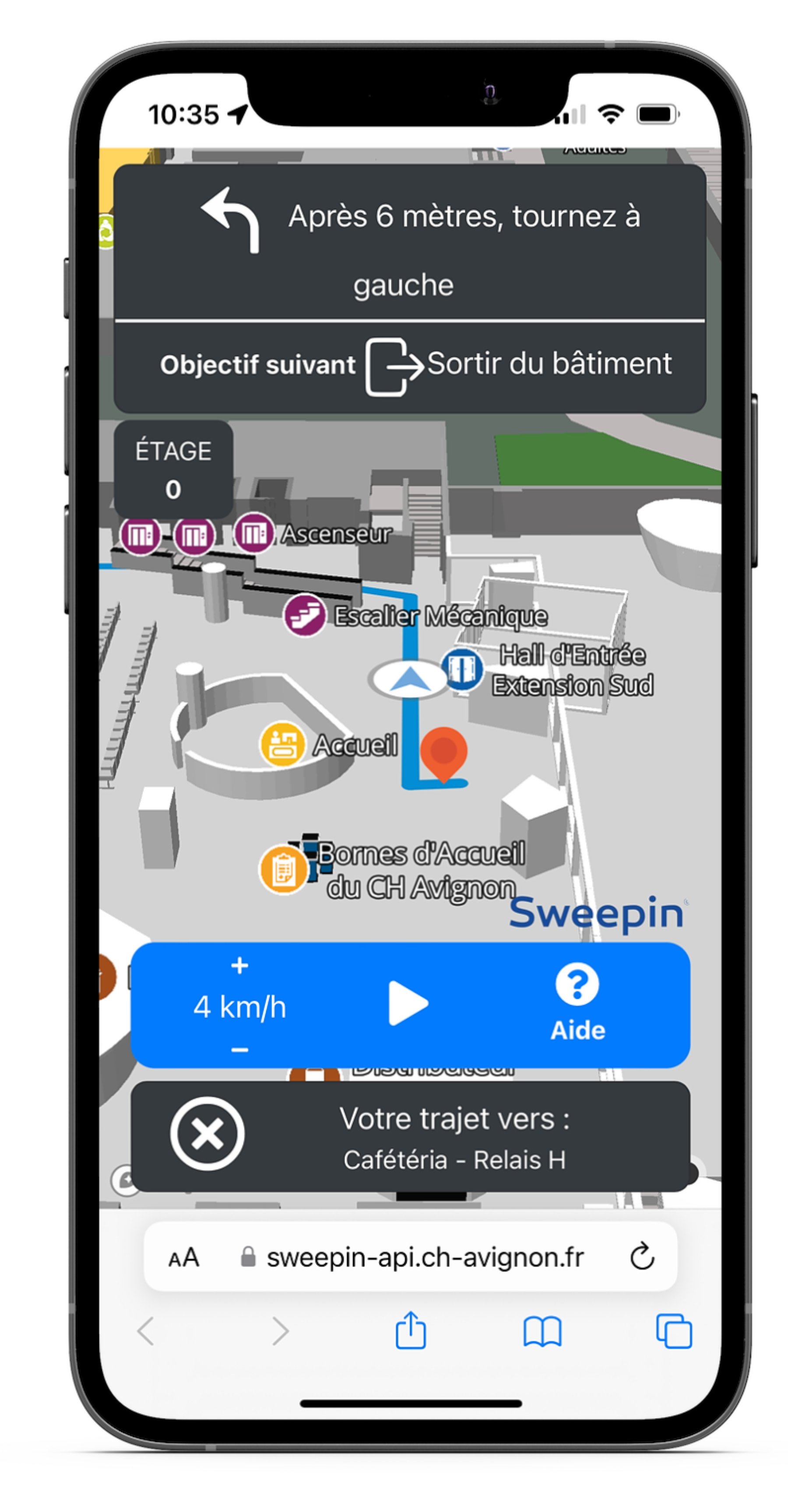
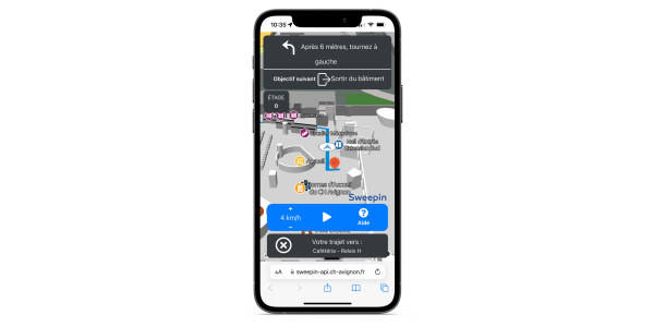
In this case, each QR code corresponds to the user's starting position in a building, such as a hospital for example. Once the QR code is scanned by the visitor with his smartphone, the map of the place is displayed on the screen. He is offered to generate an itinerary according to his position (found thanks to the QR code) and the place where he wants to go.


A button "start guiding" is then displayed and the visitor can choose his walking speed to follow the proposed route. He also has the possibility to pause the route at any time.


The availability of QR codes


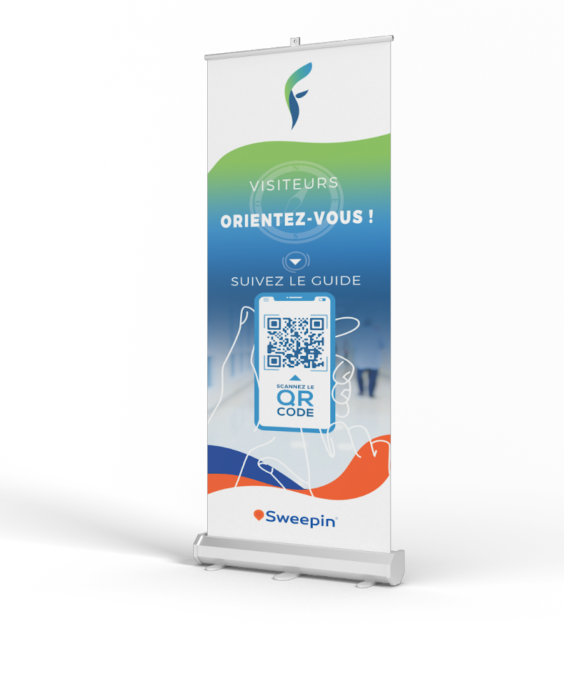
Using this solution, the provision of QR codes for visitors is essential. It is possible to print them on posters or kakemonos for example, or to generate them on the digital terminals of the building. The main thing is that visitors find them quickly and easily in places that are often very spacious and busy. 


Les avantages de cette solution de guidage intérieur


Combining 3D mapping with the use of QR codes has several advantages.


First of all, this solution does not require the prior installation of a mobile application by the visitors and allows them to guide themselves in the building without necessarily having anticipated this route search.


Moreover, the implementation of this guidance system is very simple because it does not require any installation, except for the kakemonos, posters or digital terminals of reception to display the QR codes. This means that the Sweepin team does not have to travel to help set up the service, as everything can be easily indicated remotely if necessary. 


Another advantage is that visitors can go directly to the desired location without getting lost in a large structure. The staff also benefits from the reduction of corridor clutter, especially in health care facilities. 


Finally, this solution can be adapted to many types of structures with large surfaces, such as healthcare institutions, trade shows, exhibitions, etc. Sweepin was responsible for the 3D mapping at the SANTEXPO trade fair in 2022 and is currently providing this solution to several healthcare institutions in France.


An access to statistics generated by the solution 


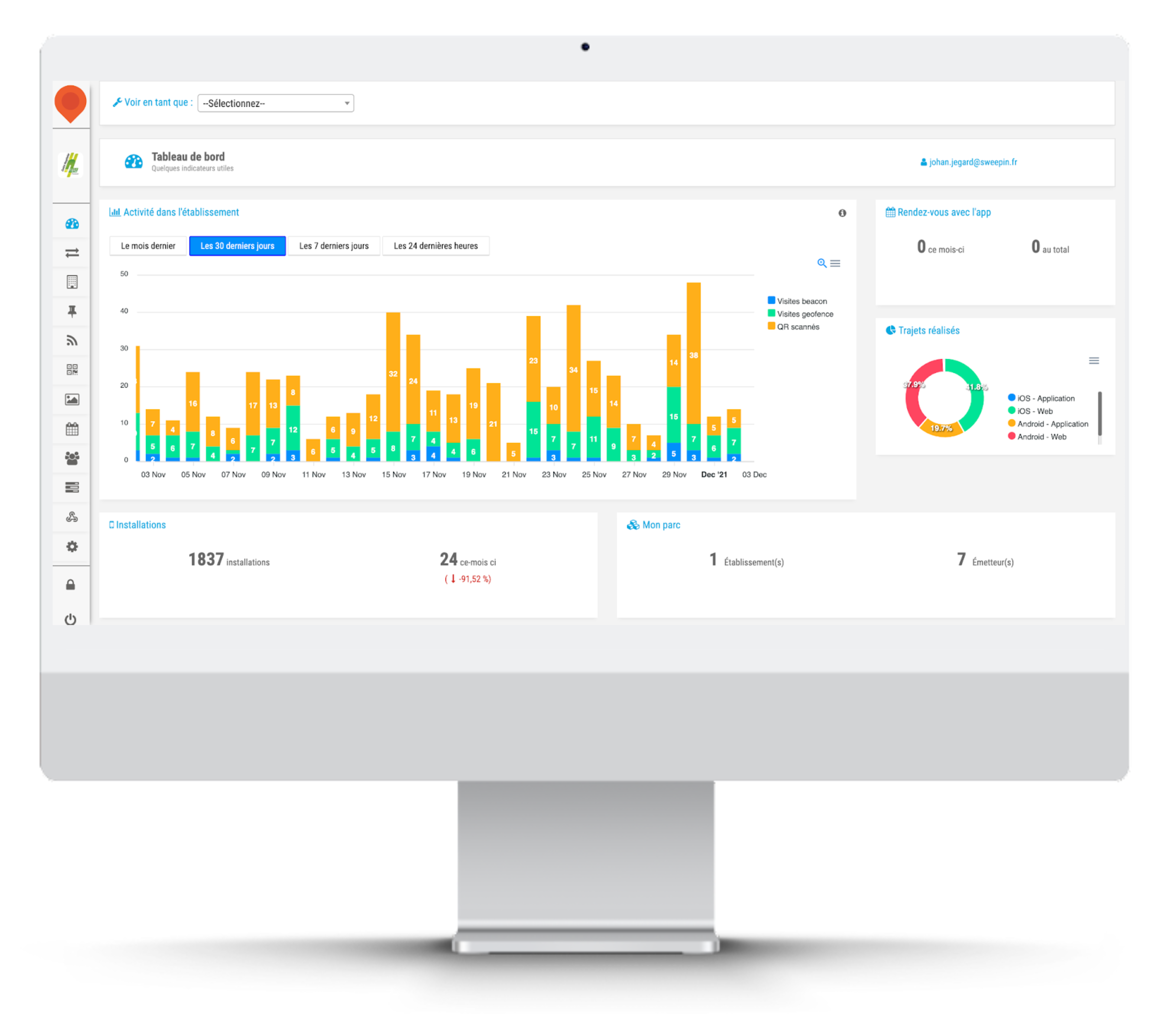
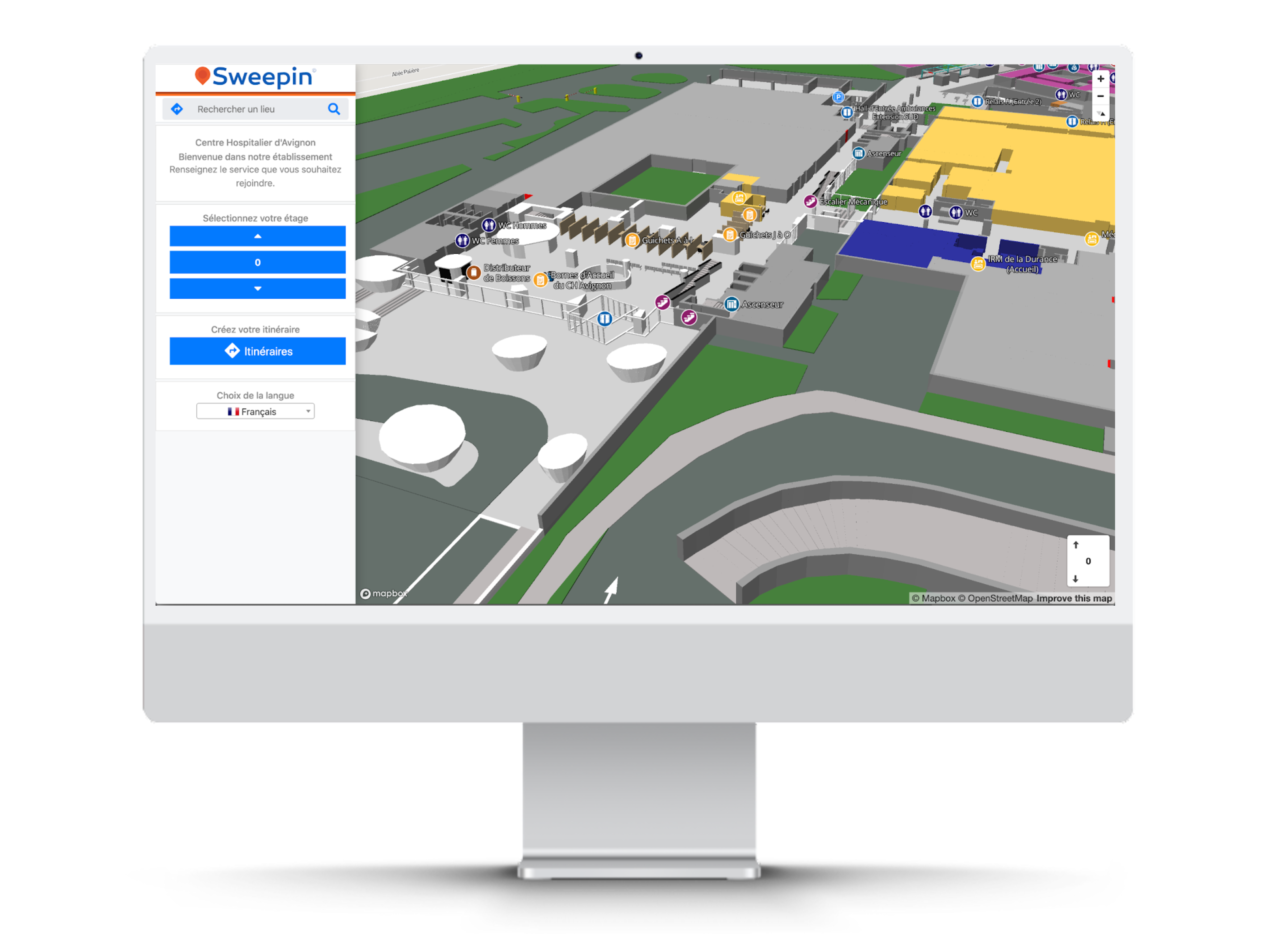
From the Sweepin back-office, it is possible to access numerous statistics on the use of the solution. 


For example, you can see how many QR codes have been scanned since the solution was implemented, but also during the last 24 hours, the last week or the last month.


It is also possible to see which QR codes are the most scanned by visitors, as well as their number of scans. 


These statistics make it possible to report on the effectiveness of the solution and to adapt it to the building in which it is deployed.


Connected city, smart city… These expressions are often used as synonyms, but isn't this an abuse of language? Is there a difference between these two concepts? Answers in this article.


What is a smart city ?


The concept of smart city, which appeared in Korea in the early 2000s, was popularized by former U.S. President Bill Clinton. For him, it is a sustainable city, with a low ecological impact and pleasant to live in. He then challenged companies specialized in computer networks to put their technology at the service of this city of the future and its inhabitants.


Today's smart cities are environmentally friendly and energy efficient, thanks to intelligent systems that enable them to anticipate their consumption: smart grids for water and energy management, sensors to manage public lighting, etc. It is also a place of exchange, where city services and citizens communicate via applications to improve city life together.


And what is the connected city ?


The connected city is a smart city! At the time when Clinton evokes the concept of smart city, we are at the very beginning of 2.0. The notion of participative economy was still in its infancy for the average citizen, and artificial intelligence was almost science fiction. The city then became, at first, a connected space through the use of technology. The goal is to improve the efficiency of processes to become more economical and ecological.


With the rapid evolution of technologies and mentalities, the city connected by purely technological means has then become an interactive space, in which residents participate in city decisions from their smartphones (citizen reporting, polling, etc.). It is a place for citizen dialogue, which brings people together, where everyone can take concrete action on their quality of life.


Smart city, connected city… So, different or not?


Connected city or smart city, the concept covers the same reality: that of a city optimized by technology. But is it really the same thing? Globally, yes, because to be smart, a city must be connected, and if it is connected, it has every chance of becoming intelligent, more sober on the ecological and economic level, and more inclusive on the social level.


There is, however, a semantic nuance. The notion of smart city refers to a thought, a real concept of urban planning in which we "build" a more sustainable and human city, while the term connected city refers rather to the practical aspect and the operational means to achieve it (open data, networked operation, mobile application, sensors, video protection cameras, etc.).


But whether it is called connected or smart, the city will only be a sustainable and pleasant place to live if it uses technology in a thoughtful way, with specific objectives: facilitating community life, reducing electricity consumption, optimizing waste collection, etc. Above all, it requires a real project and a municipal will to make technology an asset in the development of its territory.


Start your connected and smart city project with our applications with customizable services.


Interior mapping is the essential tool for finding your way around a building. Without it, you can only rely on your sense of direction to find your way around a building. This digital version of a map facilitates our understanding of spaces and transforms all our movements. But how does indoor mapping work in practice? Answer in this article.


Interior mapping: how does it work?


Digital interior mapping is the 3.0 version of the paper map displayed at the entrance of a building. It allows you to find your way in space in 3 dimensions, and it guides you in an intuitive and practical way to your destination. A dream tool for those who don't have a sense of direction!


To take advantage of the benefits of this solution, you first need an up-to-date building map. Just as your GPS needs the latest update of a road map to lead you to the right place by the right route, digital mapping requires up-to-date and accurate data. This map is then modeled into a 3D digital version, showing walls, elevators, stairs and floors.


Indoor mapping is a digital service but it is used without a mobile application or network. It is therefore practical and very easy to use. It is accessible via digital kiosks or via a simple QR code displayed on a kakemono at the entrance of the building. Visitors just have to scan it with their smartphone to access the map. At this point, they just need to enter their location and destination, then the video guidance system takes over to show them the way.


The concrete applications of interior mapping


Indoor mapping is mainly used to facilitate navigation and orientation of visitors. It can therefore help you find your way in any type of building, especially large complexes that receive the public (hospital, airport, station, hotel, etc.). In a warehouse, it is an effective solution to optimize the flow and facilitate the rotation of deliveries.


Because it provides a 3D view, digital mapping can also be used to locate points of interest in a building, no matter what floor they are on, such as stores on your route in a shopping mall, the mystery section in a library, or your location in an underground parking garage.


However, its applications go beyond simple orientation in a building. With indoor mapping, you can model specific routes and then make them accessible in web mode or via different QR codes. You can enhance the user experience at an event (visiting an exhibition in a museum, an open day at a university…), or increase safety by publishing routes to evacuation points in case of fire.


Indoor mapping is already the future with smart indoor travel! Discover our 3D digital mapping solution and all our indoor geolocation services on Sweepin.fr. 


A few weeks ago, we introduced you to the characteristics of the smart city. A connected and sustainable city, in which technology is truly at the service of its inhabitants. Some of the French smart cities stand out. They are even among the 100 cities labeled "climate neutral and smart cities by 2030" by the European Commission. Here are our top 5.


1.Lyon, pioneer and leader in French smart cities


Lyon has totally rethought its urban planning over the past 20 years, and has taken advantage of this to integrate technology into its sustainable city model. It is a pioneer in smart grids, which use energy resources efficiently.


For a better quality of life, it has designed fully connected, green and less concrete eco-districts, such as the Confluence district. It is acting on mobility with electric and autonomous public transport, while giving pride of place to pedestrians and bicycles.


2.Dijon and its centralized management


In our Dijon hearts, Dijon is number 1, but we tried to stay objective 😊. To reduce its energy consumption by 65% by 2030, the capital of the Dukes of Burgundy has deployed sensors and created OnDijon, a unique control center that pilots the entire public space (traffic lights, lighting, parking…).


Residents interact with city officials via a collaborative platform, initiating coordinated actions in case of accidents or damage. Dijon is also building eco-neighborhoods that promote social diversity and encourage soft mobility.


3.Nantes, the smart city


Nantes has made its data accessible to involve residents in its transformation. More than 1.5 million Nantes residents log on to the open data portal every month to share their ideas on how to use this data in practice!


The Nantes dans ma poche app allows users to report incidents or obtain real-time information (air quality, traffic, etc.). And to continue the dialogue, public consultations on the energy transition or the deployment of 5G are organized for a co-construction of the Nantes of tomorrow.


4.Paris, greener and more connected


Like Nantes, Paris uses open data to develop collaborative projects. Many efforts are being made to renovate and green buildings. Alternative and electric modes of transport are becoming more widespread, and an autonomous metro is under study… The goal is carbon neutrality by 2050!


Paris is also betting on technology with, among other things, intelligent lighting and the Dans ma rue app to report damage. Coming soon, a digital access project for all and 5G available in the metros by 2025.


5.Grenoble, the ecocity of tomorrow


As the European Green Capital in 2022, Grenoble has developed its smart city project around the Cambridge eco-district, with the ambition of being an energy positive and carbon neutral territory.


The city has created a low temperature heating and cooling network. It manages all its energy flows with smart grids. It has also set up the Grenoble CivicLab for the participatory design of the city's digital services.


Montpellier, Bordeaux, Strasbourg, Roubaix, Chartres… Many cities are now intelligent. Discover how to connect yours with our services.


Location systems or GPS have become more and more important in our daily lives by simplifying our journeys, regardless of our destination. But what about our movements or the location of objects in buildings? For the past 15 years, indoor geolocation has been making steady progress to provide an effective answer to this question. Let's take a closer look at this technology with multiple uses.


Indoor geolocation in brief


You may have heard of IPS (indoor positioning system), indoor positioning or indoor geolocation? All these terms are synonymous with indoor geolocation, and refer to a set of technological solutions that allow the location of goods or people in closed spaces (buildings, houses, etc.).


For its implementation, indoor geolocation relies on several location technologies: Bluetooth beacons, RFID chips, Wifi and UWB signals for radio technologies, but also ultrasonic signals or the magnetic field. Depending on their shape and the desired use, they are disseminated in the building or mapped. The signals they emit are then picked up by various mobile devices, such as your smartphone or a touch pad.


Thus, indoor geolocation allows you to establish your position with an accuracy ranging from a few centimeters to several meters depending on the technology used, but also determine the route to take to reach your destination or the object sought.


Why not use a GPS?


Simply because GPS does not work indoors. Yes, this little jewel of technology that allows even those who have no sense of direction to find their way around the world, is unable to orient you in a building located around the corner! Why not?


In order to determine your position outdoors, GPS uses the radio signals emitted by the various satellites orbiting the Earth, but once inside, these signals are blocked by various obstacles (walls, roof, furniture …). The most recent GPS systems do receive a signal indoors, but their accuracy is still insufficient for proper orientation.


The other problem with a traditional GPS is that it processes the signal in a linear fashion, so it can't determine what floor you're on. Moreover, its signal decreases as you go downstairs, until it disappears in the basement. Hence the usefulness of an indoor geolocation system.


What are the applications of indoor geolocation?


Whether marketing, commercial or purely practical, the applications of indoor geolocation are numerous:


  • Navigation and orientation in a public or private site (airport, hospital, shopping mall...) via a mobile application or a QR code,
  • Behavioral analysis and flow optimization in a commercial space or a secured place (industrial site, military complex...),
  • Gofencing: sending information to the user when he is in a specific area (promotional offers, security alerts...),
  • Interaction with an object in the immediative vicinity (product, work of art...), etc.


The combination of different indoor geolocation technologies is managed via a platform, which can be integrated into the building information system. Sweepin offers innovative, unique and patented indoor geolocation technologies. Discover all our solutions on sweepin.fr.


The smart city is an original urban development concept that makes the life of city dwellers more pleasant and the management of territories more efficient thanks to technology. But what exactly is a smart city? How does it work and how is it connected? Here are some explanations.


Smart city, the city at the service of its inhabitants


Smart city, connected city, sustainable city… these innovative concepts have been around for about ten years but we know little about them. Yet they meet the aspirations of many French people who are looking for meaning in their daily lives: being more involved in the community, saving resources, communicating simply, using efficient public services…
Public authorities are often perceived as immovable systems, not very agile in their mode of operation and in the answers they provide to citizens. A deaf and blind system, in which today's citizens have difficulty making their needs heard and sharing their ideas.


In a smart city, or a smart territory outside the metropolis, it is the opposite. City services use digital tools to exchange with residents and improve their operational efficiency in managing infrastructures: transportation, urban planning, health, environment, etc. It's the city 3.0 at the service of its residents.


How does a connected city work?


The objective of a smart city is to make the city a sustainable space in several ways:


  • Offer a better quality of life through active paticipation of citizens,
  • develop envrionmental initiatives based on sustainable urban planning, intelligent resource management and the growth of the local economy,
  • Improving public services, especially by making administration efficient and urban transport effective.


To achieve this, communities rely on technology, such as applications to exchange open data with citizens, and artificial intelligence to improve infrastructure and provide an agile response to residents' needs. In this sense, the smart city is also a connected city.


More collaborative, more agile, the smart city is also more ecological and more efficient. Let's not forget that smart also means astute, clever; the smart city therefore skillfully combines the advantages of technology with collective intelligence for a better quality of life and service.


Smart cities and their concrete applications


A smart city is in a way the proximity of yesterday (exchanging on the village square) with the technology of today (the Internet of Things) to build the life of tomorrow (ecological and pleasant spaces to live).


However, there is no single mode of action. Each smart city develops its vision of the ideal smart city and chooses the technology to get there: citizen reporting apps, connected services to promote local commerce, sensors to improve waste collection…


Lyon relies on passive construction and smart grids to adjust electricity supply. Nantes uses open data and an app dedicated to mobility (real-time traffic, incidents on public roads, etc.). Dijon centralizes the management of urban equipment (traffic lights, video protection, etc.) and saves money with LED lighting. And for you, what is the ideal smart city?