johan Jegard


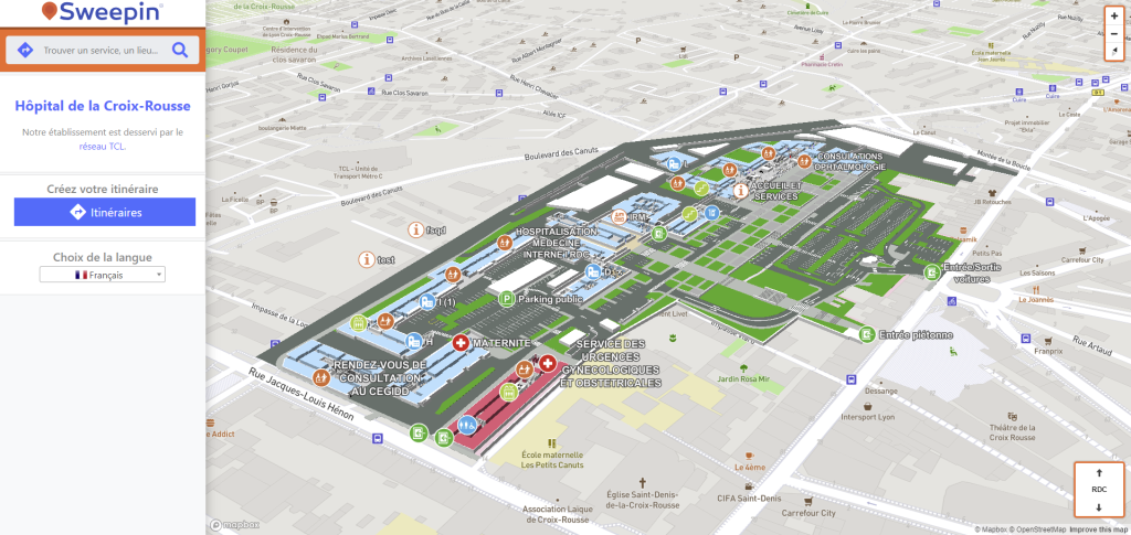
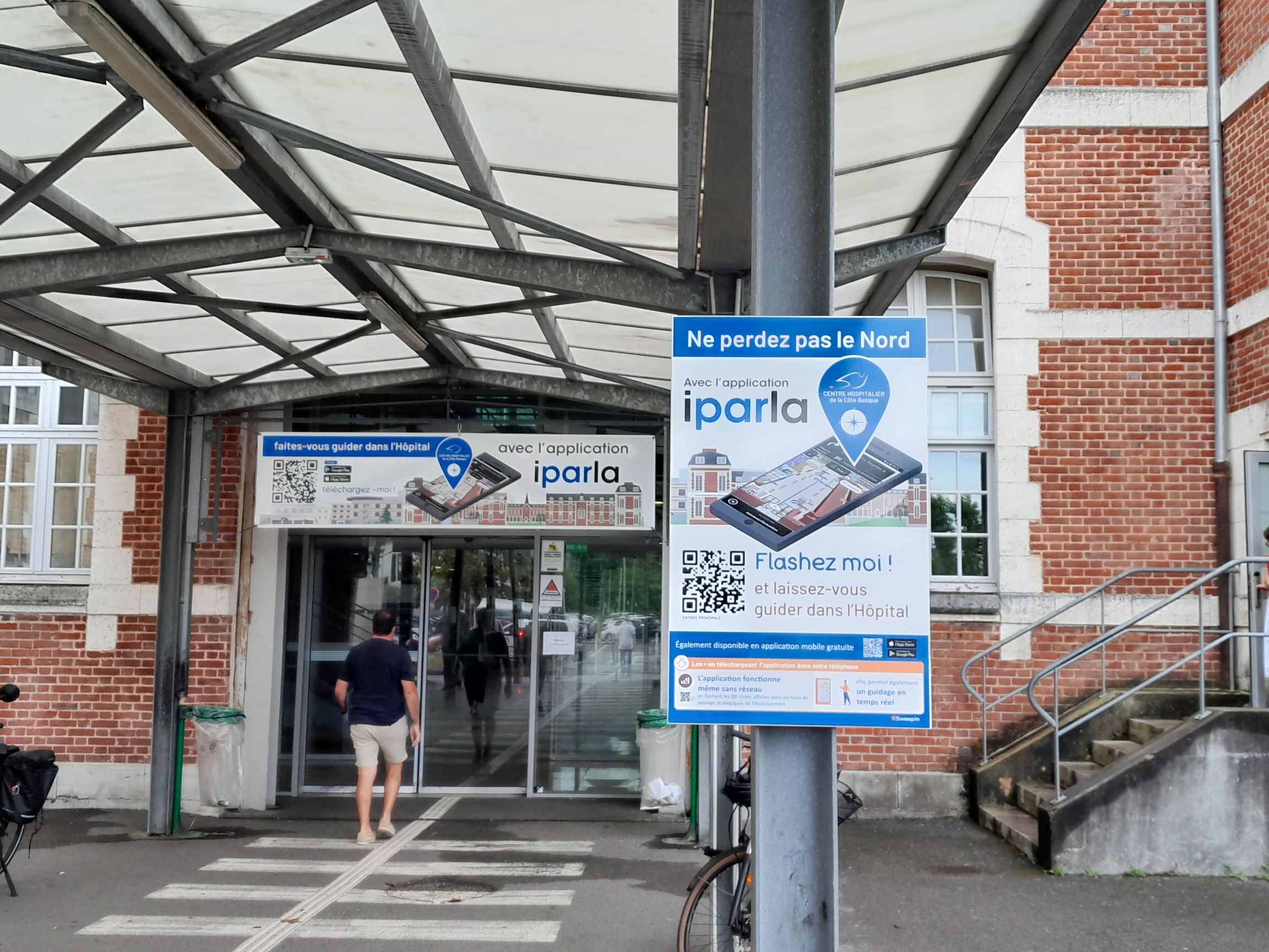
In order to provide indoor geolocation services, companies like Sweepin have to rely on 3D mapping of an establishment's buildings.


3D mapping, the basis of indoor geolocation


3D mapping of a building is a detailed representation of its structure, offering a realistic and comprehensive perspective. Drawing up a 3D plan enables you to visualize the height, shape and layout of a building's different levels.


A connection can be made to the Digital Twin to facilitate the creation and updating of a building's cartography. The Digital Twin is a real-time virtual reconstruction of a physical object or process, used to simulate, monitor and optimize its operation. In particular, this system enables more efficient resource management by simulating different layouts and space configurations to optimize plant utilization. It also enables proposed changes to be simulated and evaluated to minimize errors and costs.


Over time, the buildings of a facility, such as a hospital, are bound to evolve, be redeveloped or even restructured. Their mapping then needs to be updated to provide a consistently accurate map for geolocation services.


Quick and easy updating of building plans with intuitive tools


Updating a building's cartography can seem tedious if it includes a lot of changes. It's up to companies like Sweepin to make updating easier, especially when the changes don't affect the building's architecture.


Once the first 3D map has been created from the architect's plans, various elements of the plan, such as style, access features and points of interest, can be easily modified. Easy-to-use tools make it possible to quickly update all these mapping elements without calling in the professionals.


The flexibility offered by these tools guarantees an accurate, up-to-date representation of the environment. In this way, the building's functional evolutions are taken into account over time. This proactive approach to updating mapping contributes to efficient space management and optimal use of resources, particularly in facilities such as hospitals.


The case of Sweepin and its 3D plan editor


Sweepin uses the Digital Twin to provide its customers with their digital cartography. In addition to this, a 3D plan editor is entirely dedicated to the company's healthcare facility customers. This editor is easily accessible by any facility wishing to update its 3D mapping. It provides a range of features to give healthcare facilities control over certain elements of their cartography whenever they wish. The interface is intuitive and fluid, and each tool is clearly identified to simplify the updating process as much as possible.


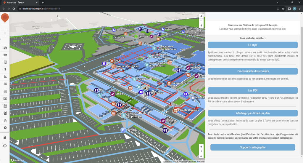
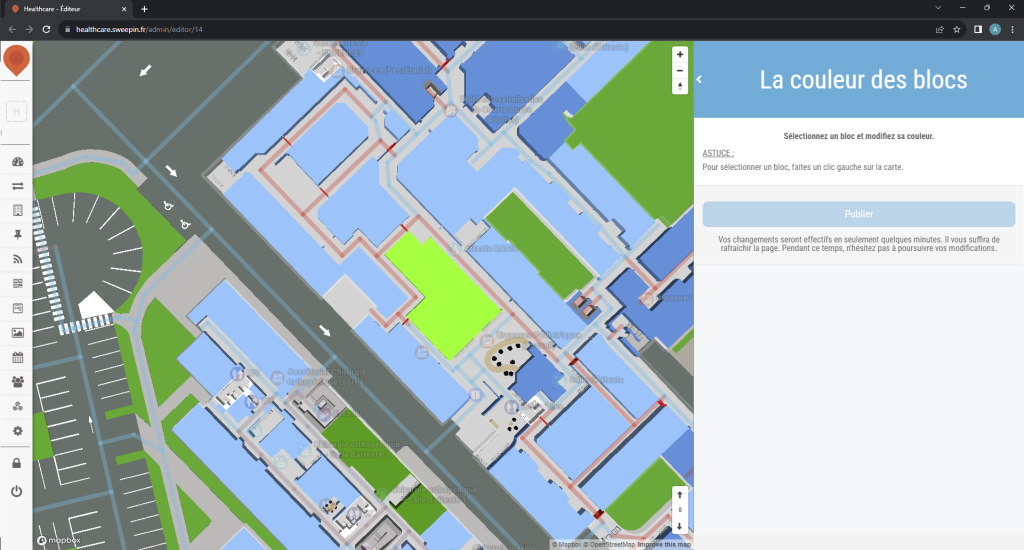
The style of a building can be easily modified, including its color. Changing the color helps to distinguish each department of a healthcare facility. It can be changed at will, but always strategically, especially when a department moves from one building to another.


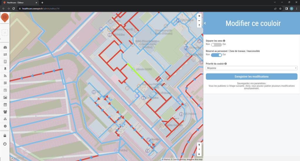
If required, it is also possible to quickly and easily change the accessibility of a building's corridors, by defining their priority and whether or not the public can use them. This can be useful for managing the flow of people through the building, or for preventing certain areas from becoming congested in an emergency.


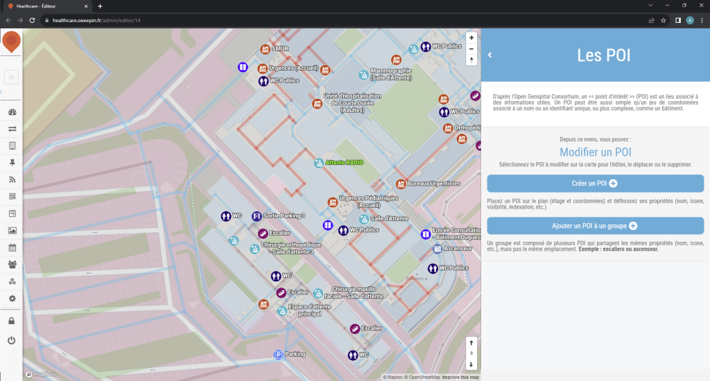
Finally, it is also possible to add, modify or delete points of interest in a building, in case some of them change location or are removed during relocations.


Major modifications, particularly to the building's architecture, can be carried out either via an automatic update of the Digital Twin, or by specialists due to their technical complexity and the time required to carry them out.


💡SDED 52, the Syndicat Départemental de l'Énergie et des Déchets de Haute-Marne application made in Sweepin is, to date, the first native non-governmental application to have integrated connection with France Connect!


✅This login system simplifies access to online services, saving time for users, who can use different accounts to log in:


  • Impots.gouv.fr


  • MSA


  • Ameli.fr


  • Yris


  • L'identité Numérique La Poste


  • France Identité


This universal authentication saves time and strengthens user account security.


Find the app on iOS and Android stores now!


Hospices Civils de Lyon has launched its new interior guidance system for patients and visitors to its facilities.


🧭This solution, provided by Sweepin, makes it easier to get around the Hospices Civils de Lyon by offering web guidance based on 3D mapping of hospital buildings. Maps are accessible on the HCL website, enabling patients to plan their route from home.


📱On-site, patients and visitors can scan QR codes to obtain a personalized itinerary, adjustable to their walking pace. Convocations also include QR codes linked to the hospital facility.


✅This device improves orientation, saves time, optimizes queues, and is suitable for people with reduced mobility, the visually impaired and the hard of hearing, thanks to audio and visual instructions.


The Sweepin team would like to thank the Hospices Civils de Lyon for their confidence in this project, which contributes to improving the day-to-day patient experience.


Example of a map¹ and itinerary generated² in the Croix-Rousse Hospital:


¹ map of the Croix-Rousse Hospital


² Itinerary generated in the Croix-Rousse Hospital


The Sweepin team is delighted to unveil its latest mobile application in collaboration with the Urban Community of Dunkerque (CUD): Corsaire.


Corsaire: Dunkirkers' daily companion


The Corsaire app has been designed to meet the needs of modern urban life and simplify the daily lives of Dunkirk residents. Here are just a few of the features that make it an indispensable tool:


Stay informed: Instantly receive the latest news from Dunkirk right in the palm of your hand, keeping you up to date with local news and events.


Plan your day: Explore an agenda of upcoming events in the region and add them to your own calendar so you don't miss a thing.


Simplified journeys: Consult public transport timetables and easily locate stops using the interactive map, allowing you to navigate the city with ease.


Report & interact: Report problems in the city, carry out administrative procedures and enjoy a full range of other practical features for seamless interaction with your urban environment.


The Corsaire app transforms urban life into a fluid, connected experience, offering Dunkirk's citiz


The app is available for free download now on the Android and Apple stores. Don't miss the opportunity to discover the benefits that will help simplify your daily life in Dunkirk and strengthen your connection with this dynamic city.


We would like to thank the Communauté Urbaine de Dunkerque for their trust and collaboration in the creation of Corsaire!


We're delighted to announce the launch of our latest mobile application: Vitaboucle. The fruit of our collaboration with the city an Eurometropolis of Strasbourg, this sports app invites you to discover the city in an active way, while taking care of your health.


Vitaboucle: explore Strasbourg in motion thanks to innovative features


The Vitaboucle application has been designed to offer a unique experience to the citizens of Strasbourg:


Customized routes: discover Vitaboucle routes tailored to your specific needs and preferences, allowing you to enjoy the city to the full, whether you're on your own or accompanied by loved ones.


Points of interest: explore all Strasbourg's landmarks and access all relevant information directly from the app.


Diary and events : Stay on top of all the city's events with our comprehensive calendar. You can even add these events to your personal calendar.


News and notifications: Keep up to date with the latest news and developments in Strasbourg with real-time notifications.


Vitaboucle offers an original way to discover Strasbourg while staying active and committed to your health. The app is available free of charge on Android and Apple platforms.


We would like to thank the city of Strasbourg for its invaluable collaboration, which has enabled us to offer citizens this unique and energizing experience.


Around the world, connected cities are gaining ground, and with them, the use of mobile applications is becoming the norm. These mobile applications can make a significant contribution to enhancing the safety of a city's inhabitants, by facilitating communication between the various players involved in safety, enabling the rapid reporting of incidents or dangerous situations, and facilitating the intervention of emergency services in the event of an emergency.


Mobile reporting applications for incidents


Mobile applications with a module for reporting incidents or dangerous situations on the public highway are gaining in popularity in smart cities. They enable citizens to quickly notify the appropriate authorities in the event of a problem. These applications can be used to report incidents such as road safety problems, acts of vandalism, fires, medical emergencies and so on.


These applications allow users to take photos or videos to describe the incident in greater detail. The data collected is then forwarded to the reports management service, which assesses the situation and deploys help if necessary.


Reports can be made anonymously by people who fear reprisals, or who do not wish to be involved in an investigation, for example.


As well as facilitating the reporting of incidents, these applications can also help the authorities to collect data on incidents occurring in the city. This data can then be used to identify the areas most at risk, to draw up action plans and improve safety, and finally to evaluate the effectiveness of the safety measures put in place on the territories.


It is important to note that for these mobile applications to be effective, it is necessary to ensure that the relevant authorities have the necessary resources to manage the information received and respond rapidly to emergency situations. It is also important to make citizens aware of the use of these applications, and to explain to them how to report incidents automatically and effectively.


Geolocation: a major asset for emergency services


Geolocation is another key tool for enhancing safety in connected cities. Mobile applications can use geolocation to enable emergency services to quickly locate people in danger during an emergency situation. This enables them to respond more quickly and effectively.


Real-time awareness and communication


Mobile applications also serve as communication channels, informing citizens in real time of dangers and instructions to follow in the event of an emergency, often via instant notifications.


Mobile applications represent a powerful lever for improving urban safety, in particular by optimizing communication between the various safety stakeholders. Find out more about our reporting module and all the other features available on our website!


Sweepin is delighted to unveil its latest creation in collaboration with the Syndicat Départemental d'Énergie et des Déchets de Haute-Marne (SDED 52): the SDED 52 mobile application. This application has been specially developed for the citizens of Haute-Marne, with the aim of making their daily lives even more fluid and practical.


SDED 52 chose Sweepin to create an ingenious solution combining household waste management and public electricity distribution services. The objective was simple: to improve exchanges between SDED, local councillors and citizens, while guaranteeing optimum responsiveness to the challenges facing our public service.


The SDED 52 application offers a variety of features to simplify the lives of Haute-Marne residents:


Fast reporting: Easily report problems on the public highway and track their resolution in real time, thanks to notifications received via the mobile app.


Waste management: Find out which waste collection days are specific to your address and access a practical sorting guide to help you manage your waste more efficiently.


Useful proximity: Locate nearby electric vehicle charging stations and waste collection centers, making your commitment to a more sustainable lifestyle easier.


Local news: Stay informed about events and news relevant to your region.


Everyday eco-gestures: Adopt simple, ecological gestures to preserve the environment and reduce your carbon footprint.


SDED 52 is available free of charge on Android and Apple platforms. Download it now to benefit from an enriching experience that will considerably improve your daily life in Haute-Marne.


Healthcare facilities are demanding environments where staff safety is an absolute priority. Geolocation, when used thoughtfully and ethically, proves to be a powerful tool for reinforcing this security. In this article, discover the benefits of using geolocation to protect staff, thanks to solutions like the one offered by Sweepin.


Enhanced employee safety


Staff safety in healthcare establishments is paramount, and geolocation offers an effective means of reinforcing it. When a member of staff feels in danger, solutions have been developed so that they can easily raise the alarm and be helped as quickly as possible.


For example, by being equipped with a badge or smartwatch, he can trigger an alert and thus activate his geolocation, enabling the security team to know his exact position instantly. This feature can save lives, as it enables faster intervention in the event of an emergency. By knowing where the person in distress is, rescue teams can reduce response times and maximize the chances of saving lives.


Staff stress is reduced and their privacy preserved


Thanks to this reinforced protection, staff stress and anxiety are reduced. Less stressed staff are more productive and healthier, which benefits staff, facilities and patients alike, who need the best possible care.


One of the key advantages of using geolocation via a smartwatch or badge is that it is not permanent. Geolocation is only activated when staff want it to be, by triggering an alert, thus guaranteeing their privacy and reinforcing their sense of security.


Incident documentation


Geolocation provides a digital trace of incidents, which can prove invaluable for internal investigations, safety reports and the prevention of potential future incidents. Accurate documentation contributes to in-depth analysis and the development of effective long-term solutions to ensure everyone's well-being and safety.


The thoughtful use of geolocation for personnel protection in healthcare facilities brings undeniable benefits in terms of safety, staff and patient wellbeing, but also in terms of prevention. It is imperative that companies offering these services put in place clear policies and comply with local regulations to ensure ethical and responsible use of this technology, while obtaining staff consent. Find out more about Sweepin's staff protection solution for healthcare facilities!


In order to simplify the lives of its citizens, the Metropole de Bordeaux has called on our services to develop a mobile application for citizens: Ma Ville Facile. Residents of the Bordeaux metropolis can now access essential information and manage their daily lives much more easily.


Ma Ville Facile ! offers a fully customizable, feature-rich experience to enhance the quality of life in the region.


Personalized access to local information


One of the outstanding features of Ma Ville Facile is its ability to adapt to your individual needs. Thanks to the multi-city choice function, users can select their preferred city from Le Bouscat and Blanquefort to access relevant information quickly and efficiently.


Everything you need in a single mobile app


The Ma Ville Facile application has been designed to simplify the daily lives of Bordeaux Métropole residents. It offers a wide range of functions, including :


  • essential information: stay informed with local weather, air quality, news and a complete calendar of events in your city.


  • interactive directory: an interactive directory of local businesses with filters to help you find a restaurant, store or local service.


  • transport made easy: easily obtain public transport timetables, locate nearby stops and plan your journeys in no time at all.


  • reporting: help make your community safer and more responsive by reporting problems on the public highway directly from the application.


  • Waste sorting: Be an eco-responsible citizen by consulting the waste collection days and learning how to sort correctly.


  • citizen polls: take an active part in the life of your region by expressing your expectations and contributing to important decisions through citizen polls.


We would like to thank Métropole de Bordeaux for this opportunity to collaborate and create a unique application that will help improve the daily lives of Bordeaux's inhabitants.


Ma Ville Facile ! is available free of charge on the Android and Apple stores!


Yesterday, the Saint-Léon site of the Centre Hospitalier de la Côte Basque launched its new interior guidance system for patients and visitors, developed by Sweepin.


2 options to guide you easily to your meeting place at the facility:


✅ With your smartphone, scan the QR codes available throughout the site, choose your destination and let us guide you to your desired location.


📱Before your visit, download the new iparla mobile app free of charge. Choose your destination in the hospital and let it guide you from anywhere to your appointment location in the facility. The mobile app works without a network and provides real-time guidance!


Thank you to the Centre Hospitalier de la Côte Basque for their confidence in this project, in which we are proud to have participated!


Learn more : https://www.ch-cote-basque.fr/actualites-du-chcb/2668-amelioration-de-l-orientation-du-public-sur-le-site-saint-leon-lancement-du-dispositif-et-de-l-application-iparla


They talked about it:


Ici, by France Bleu and France 3 : https://bit.ly/42To5fg